Rāmpur geodata
Rāmpur (Himachal Pradesh) is a populated place; located in India in Asia/Kolkata (GMT+5.5) time zone. With population of 6,206 people, there are 3269 cities with bigger population in this country. Compared to other cities in India, 96.8% of cities are located further ↓South; 55.6% of cities are located further →East and 96.1% of cities have lower elevation than Rāmpur. Note1


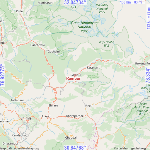
Rāmpur GPS coordinates[2]
31° 26' 57.948" North, 77° 37' 51.132" East
| Map corner | latitude | longitude |
|---|---|---|
| Upper-left | 32.04734°, | 76.92775° |
| Center: | 31.44943°, | 77.63087° |
| Lower-right: | 30.84768°, | 78.334° |
| Map W x H: | 133.4×133.4 km | = 82.9×82.9mi |
| max Lat: | 34.9274° ⇑3.2% North |
| Rāmpur: | 31.44943° |
| min Lat: | ⇓96.8% South 8.09008° |
| min Long | Rāmpur | max Long |
| 68.82655° | 77.63087° | 96.81° |
| W 44.4%⇐ | ⇒55.6% E |
Elevation
Elevation of Rāmpur is 992 m = 3255 ft, and this is 696.4 m = 2285 ft above average elevation for this country.
| Max E: |
3681 m = 12077 ft | 3.9% |
| Rāmpur | 992 m 3255 ft | |
| Avg. | 295.6 m = 970 ft | |
Min E: |
1 m = 3 ft | 96.1% |
See also: India elevation on elevation.city.
Geographical zone
Rāmpur is located in North temperate zone (between Tropic of Cancer and the Arctic Circle). Distance of this Northern Tropic circle is 890.9 km =553.6 mi to South.| Distance of | km | miles | from Rāmpur |
|---|---|---|---|
| North Pole | 6510.2 | 4045.2 | to North |
| Arctic Circle | 3904.3 | 2426 | to North |
| Tropic Cancer | 890.9 | 553.6 | to South |
| Equator | 3496.8 | 2172.8 | to South |


Nearby cities:
15 places around Rāmpur: (largest is in red/bold)
• Arki
71.2 km =44.2 mi,  242°
242°
• Banjār
34.7 km =21.6 mi,  307°
307°
• Chaupāl
56.1 km =34.9 mi,  184°
184°
• Jubbal
37.9 km =23.5 mi, 177°
• Jutogh
62.4 km =38.8 mi,  231°
231°
• Kotkhai
37.9 km =23.5 mi,  193°
193°
• Mandi
72.3 km =44.9 mi,  293°
293°
• Nārkanda
26.8 km =16.7 mi,  216°
216°
• Pāndoh
59.9 km =37.2 mi, 294°
• Rohru
29.9 km =18.6 mi,  156°
156°
• Sarāhan
16.9 km =10.5 mi,  66°
66°
• Seoni
53.4 km =33.2 mi, 244°
• Shimla
58.5 km =36.4 mi, 228°
• Sundarnagar
69.5 km =43.2 mi,  277°
277°
• Theog
44.7 km =27.8 mi, 215°
Sources, notices
• [Note1] Compared only with cities in India existing in our database
• [Src1] Map data: © OpenStreetMap contributors (CC-BY-SA)
• [Src2] Other city data from geonames.org with taken over terms of usage.
• [Src3] Geographical zone / Annual Mean Temperature by Robert A. Rohde @ Wikipedia
