Bhaisa geodata
Bhaisa (Telangana) is a populated place; located in India in Asia/Kolkata (GMT+5.5) time zone. With population of 46,120 people, there are 959 cities with bigger population in this country. Compared to other cities in India, 68.3% of cities are located further ↑North; 51.6% of cities are located further →East and 73.6% of cities have lower elevation than Bhaisa. Note1


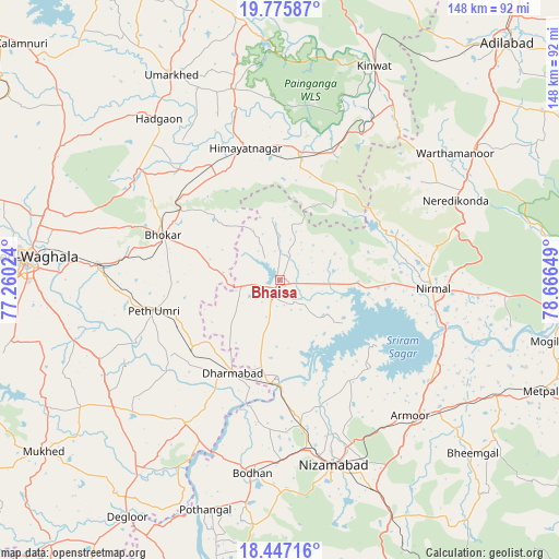
Bhaisa GPS coordinates[2]
19° 6' 46.26" North, 77° 57' 48.096" East
| Map corner | latitude | longitude |
|---|---|---|
| Upper-left | 19.77587°, | 77.26024° |
| Center: | 19.11285°, | 77.96336° |
| Lower-right: | 18.44716°, | 78.66649° |
| Map W x H: | 147.7×147.7 km | = 91.8×91.8mi |
| max Lat: | 34.9274° ⇑68.3% North |
| Bhaisa: | 19.11285° |
| min Lat: | ⇓31.7% South 8.09008° |
| min Long | Bhaisa | max Long |
| 68.82655° | 77.96336° | 96.81° |
| W 48.4%⇐ | ⇒51.6% E |
Elevation
Elevation of Bhaisa is 369 m = 1211 ft, and this is 73.4 m = 241 ft above average elevation for this country.
| Max E: |
3681 m = 12077 ft | 26.4% |
| Bhaisa | 369 m 1211 ft | |
| Avg. | 295.6 m = 970 ft | |
Min E: |
1 m = 3 ft | 73.6% |
See also: Bhaisa elevation on elevation.city.
Geographical zone
Bhaisa is located in North Torrid zone (between Equator and Tropic of Cancer). Distance of this Northern Tropic circle is 480.8 km =298.8 mi to North.| Distance of | km | miles | from Bhaisa |
|---|---|---|---|
| North Pole | 7881.9 | 4897.6 | to North |
| Arctic Circle | 5276 | 3278.4 | to North |
| Tropic Cancer | 480.8 | 298.8 | to North |
| Equator | 2125.1 | 1320.5 | to South |


Nearby cities:
15 places around Bhaisa: (largest is in red/bold)
• Biloli
45.3 km =28.1 mi,  213°
213°
• Bodhan
50.8 km =31.6 mi,  189°
189°
• Bānswāda
82.3 km =51.1 mi, 186°
• Dasnapur
83.3 km =51.8 mi,  43°
43°
• Dharmābād
27.4 km =17 mi, 205°
• Dīglūr
74.8 km =46.5 mi, 212°
• Hadgāon
53.2 km =33.1 mi,  323°
323°
• Kinwat
62.1 km =38.6 mi,  23°
23°
• Kondalwādi
39.6 km =24.6 mi, 210°
• Mudkhed
48.6 km =30.2 mi,  275°
275°
• Mukher
77.2 km =48 mi,  234°
234°
• Nanded
68.3 km =42.4 mi,  274°
274°
• Nirmal
40 km =24.9 mi,  92°
92°
• Nizāmābād
51.1 km =31.8 mi,  163°
163°
• Umarkhed
61.5 km =38.2 mi,  332°
332°
Sources, notices
• [Note1] Compared only with cities in India existing in our database
• [Src1] Map data: © OpenStreetMap contributors (CC-BY-SA)
• [Src2] Other city data from geonames.org with taken over terms of usage.
• [Src3] Geographical zone / Annual Mean Temperature by Robert A. Rohde @ Wikipedia
