Bodhan geodata
Bodhan (Telangana) is a populated place; located in India in Asia/Kolkata (GMT+5.5) time zone. With population of 73,938 people, there are 593 cities with bigger population in this country. Compared to other cities in India, 69.9% of cities are located further ↑North; 52.5% of cities are located further →East and 74.1% of cities have lower elevation than Bodhan. Note1


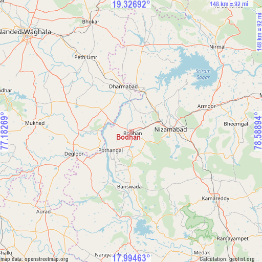
Bodhan GPS coordinates[2]
18° 39' 43.488" North, 77° 53' 8.916" East
| Map corner | latitude | longitude |
|---|---|---|
| Upper-left | 19.32692°, | 77.18269° |
| Center: | 18.66208°, | 77.88581° |
| Lower-right: | 17.99463°, | 78.58894° |
| Map W x H: | 148.1×148.1 km | = 92×92mi |
| max Lat: | 34.9274° ⇑69.9% North |
| Bodhan: | 18.66208° |
| min Lat: | ⇓30.1% South 8.09008° |
| min Long | Bodhan | max Long |
| 68.82655° | 77.88581° | 96.81° |
| W 47.5%⇐ | ⇒52.5% E |
Elevation
Elevation of Bodhan is 375 m = 1230 ft, and this is 79.4 m = 260 ft above average elevation for this country.
| Max E: |
3681 m = 12077 ft | 25.9% |
| Bodhan | 375 m 1230 ft | |
| Avg. | 295.6 m = 970 ft | |
Min E: |
1 m = 3 ft | 74.1% |
See also: Bodhan elevation on elevation.city.
Geographical zone
Bodhan is located in North Torrid zone (between Equator and Tropic of Cancer). Distance of this Northern Tropic circle is 530.9 km =329.9 mi to North.| Distance of | km | miles | from Bodhan |
|---|---|---|---|
| North Pole | 7932 | 4928.7 | to North |
| Arctic Circle | 5326.1 | 3309.5 | to North |
| Tropic Cancer | 530.9 | 329.9 | to North |
| Equator | 2075 | 1289.3 | to South |


Nearby cities:
15 places around Bodhan: (largest is in red/bold)
• Aurād
67.1 km =41.7 mi,  227°
227°
• Bhaisa
50.8 km =31.6 mi,  9°
9°
• Biloli
21 km =13 mi,  306°
306°
• Bānswāda
31.7 km =19.7 mi,  181°
181°
• Dharmābād
25.8 km =16 mi,  351°
351°
• Dīglūr
34.9 km =21.7 mi,  248°
248°
• Kondalwādi
20.2 km =12.6 mi,  323°
323°
• Kāmāreddi
61.3 km =38.1 mi,  128°
128°
• Medak
79.2 km =49.2 mi,  150°
150°
• Mudkhed
68.1 km =42.3 mi, 323°
• Mukher
54.8 km =34.1 mi,  275°
275°
• Nanded
81.7 km =50.8 mi, 312°
• Nirmal
68.3 km =42.4 mi,  44°
44°
• Nizāmābād
22.5 km =14 mi,  87°
87°
• Udgīr
86.4 km =53.7 mi, 249°
Sources, notices
• [Note1] Compared only with cities in India existing in our database
• [Src1] Map data: © OpenStreetMap contributors (CC-BY-SA)
• [Src2] Other city data from geonames.org with taken over terms of usage.
• [Src3] Geographical zone / Annual Mean Temperature by Robert A. Rohde @ Wikipedia
