Nizāmābād geodata
Nizāmābād (Telangana) is a populated place; located in India in Asia/Kolkata (GMT+5.5) time zone. With population of 305,438 people, there are 141 cities with bigger population in this country. Compared to other cities in India, 69.8% of cities are located further ↑North; 50.2% of cities are located further →East and 75.2% of cities have lower elevation than Nizāmābād. Note1


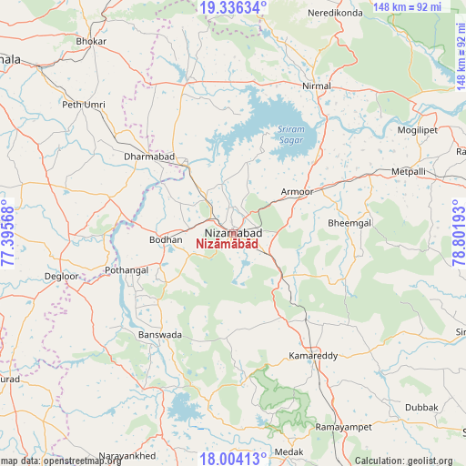
Nizāmābād GPS coordinates[2]
18° 40' 17.544" North, 78° 5' 55.68" East
| Map corner | latitude | longitude |
|---|---|---|
| Upper-left | 19.33634°, | 77.39568° |
| Center: | 18.67154°, | 78.0988° |
| Lower-right: | 18.00413°, | 78.80193° |
| Map W x H: | 148.1×148.1 km | = 92×92mi |
| max Lat: | 34.9274° ⇑69.8% North |
| Nizāmābād: | 18.67154° |
| min Lat: | ⇓30.2% South 8.09008° |
| min Long | Nizāmābād | max Long |
| 68.82655° | 78.0988° | 96.81° |
| W 49.8%⇐ | ⇒50.2% E |
Elevation
Elevation of Nizāmābād is 389 m = 1276 ft, and this is 93.4 m = 306 ft above average elevation for this country.
| Max E: |
3681 m = 12077 ft | 24.8% |
| Nizāmābād | 389 m 1276 ft | |
| Avg. | 295.6 m = 970 ft | |
Min E: |
1 m = 3 ft | 75.2% |
See also: Nizāmābād elevation on elevation.city.
Geographical zone
Nizāmābād is located in North Torrid zone (between Equator and Tropic of Cancer). Distance of this Northern Tropic circle is 529.8 km =329.2 mi to North.| Distance of | km | miles | from Nizāmābād |
|---|---|---|---|
| North Pole | 7931 | 4928.1 | to North |
| Arctic Circle | 5325.1 | 3308.9 | to North |
| Tropic Cancer | 529.8 | 329.2 | to North |
| Equator | 2076.1 | 1290 | to South |


Nearby cities:
15 places around Nizāmābād: (largest is in red/bold)
• Bhaisa
51.1 km =31.8 mi,  343°
343°
• Biloli
41 km =25.5 mi,  286°
286°
• Bodhan
22.5 km =14 mi,  267°
267°
• Bānswāda
40 km =24.9 mi,  215°
215°
• Dharmābād
35.9 km =22.3 mi,  312°
312°
• Dīglūr
56.7 km =35.2 mi,  256°
256°
• Kondalwādi
37.7 km =23.4 mi, 293°
• Koratla
66.7 km =41.4 mi,  75°
75°
• Kāmāreddi
46.7 km =29 mi,  146°
146°
• Medak
71.7 km =44.6 mi,  166°
166°
• Mudkhed
82.7 km =51.4 mi, 310°
• Mukher
77.1 km =47.9 mi, 272°
• Nirmal
53.9 km =33.5 mi,  28°
28°
• Nārsingi
77.7 km =48.3 mi, 153°
• Sirsilla
81.4 km =50.6 mi,  112°
112°
Sources, notices
• [Note1] Compared only with cities in India existing in our database
• [Src1] Map data: © OpenStreetMap contributors (CC-BY-SA)
• [Src2] Other city data from geonames.org with taken over terms of usage.
• [Src3] Geographical zone / Annual Mean Temperature by Robert A. Rohde @ Wikipedia
