Kondalwādi geodata
Kondalwādi (Maharashtra) is a populated place; located in India in Asia/Kolkata (GMT+5.5) time zone. With population of 14,770 people, there are 2486 cities with bigger population in this country. Compared to other cities in India, 69.3% of cities are located further ↑North; 54.2% of cities are located further →East and 73% of cities have lower elevation than Kondalwādi. Note1


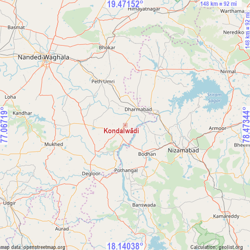
Kondalwādi GPS coordinates[2]
18° 48' 26.172" North, 77° 46' 13.116" East
| Map corner | latitude | longitude |
|---|---|---|
| Upper-left | 19.47152°, | 77.06719° |
| Center: | 18.80727°, | 77.77031° |
| Lower-right: | 18.14038°, | 78.47344° |
| Map W x H: | 148×148 km | = 92×92mi |
| max Lat: | 34.9274° ⇑69.3% North |
| Kondalwādi: | 18.80727° |
| min Lat: | ⇓30.7% South 8.09008° |
| min Long | Kondalwādi | max Long |
| 68.82655° | 77.77031° | 96.81° |
| W 45.8%⇐ | ⇒54.2% E |
Elevation
Elevation of Kondalwādi is 361 m = 1184 ft, and this is 65.4 m = 215 ft above average elevation for this country.
| Max E: |
3681 m = 12077 ft | 27% |
| Kondalwādi | 361 m 1184 ft | |
| Avg. | 295.6 m = 970 ft | |
Min E: |
1 m = 3 ft | 73% |
See also: India elevation on elevation.city.
Geographical zone
Kondalwādi is located in North Torrid zone (between Equator and Tropic of Cancer). Distance of this Northern Tropic circle is 514.7 km =319.8 mi to North.| Distance of | km | miles | from Kondalwādi |
|---|---|---|---|
| North Pole | 7915.9 | 4918.7 | to North |
| Arctic Circle | 5310 | 3299.5 | to North |
| Tropic Cancer | 514.7 | 319.8 | to North |
| Equator | 2091.2 | 1299.4 | to South |


Nearby cities:
15 places around Kondalwādi: (largest is in red/bold)
• Aurād
71.9 km =44.7 mi,  211°
211°
• Bhaisa
39.6 km =24.6 mi,  30°
30°
• Biloli
6.1 km =3.8 mi,  232°
232°
• Bodhan
20.2 km =12.6 mi,  143°
143°
• Bānswāda
49.2 km =30.6 mi,  166°
166°
• Dharmābād
12.5 km =7.8 mi,  41°
41°
• Dīglūr
35.3 km =21.9 mi,  215°
215°
• Hadgāon
77.4 km =48.1 mi,  351°
351°
• Kāmāreddi
81 km =50.3 mi,  131°
131°
• Mudkhed
47.9 km =29.8 mi,  324°
324°
• Mukher
43.8 km =27.2 mi,  255°
255°
• Nanded
61.9 km =38.5 mi,  309°
309°
• Nirmal
68.4 km =42.5 mi,  61°
61°
• Nizāmābād
37.7 km =23.4 mi,  113°
113°
• Udgīr
82.8 km =51.4 mi,  236°
236°
Sources, notices
• [Note1] Compared only with cities in India existing in our database
• [Src1] Map data: © OpenStreetMap contributors (CC-BY-SA)
• [Src2] Other city data from geonames.org with taken over terms of usage.
• [Src3] Geographical zone / Annual Mean Temperature by Robert A. Rohde @ Wikipedia
