Dharmābād geodata
Dharmābād (Maharashtra) is a populated place; located in India in Asia/Kolkata (GMT+5.5) time zone. With population of 32,351 people, there are 1346 cities with bigger population in this country. Compared to other cities in India, 68.9% of cities are located further ↑North; 53.1% of cities are located further →East and 72.8% of cities have lower elevation than Dharmābād. Note1


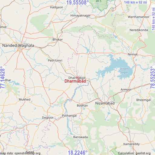
Dharmābād GPS coordinates[2]
18° 53' 28.176" North, 77° 50' 57.84" East
| Map corner | latitude | longitude |
|---|---|---|
| Upper-left | 19.55508°, | 77.14628° |
| Center: | 18.89116°, | 77.8494° |
| Lower-right: | 18.2246°, | 78.55253° |
| Map W x H: | 147.9×147.9 km | = 91.9×91.9mi |
| max Lat: | 34.9274° ⇑68.9% North |
| Dharmābād: | 18.89116° |
| min Lat: | ⇓31.1% South 8.09008° |
| min Long | Dharmābād | max Long |
| 68.82655° | 77.8494° | 96.81° |
| W 46.9%⇐ | ⇒53.1% E |
Elevation
Elevation of Dharmābād is 360 m = 1181 ft, and this is 64.4 m = 211 ft above average elevation for this country.
| Max E: |
3681 m = 12077 ft | 27.2% |
| Dharmābād | 360 m 1181 ft | |
| Avg. | 295.6 m = 970 ft | |
Min E: |
1 m = 3 ft | 72.8% |
See also: India elevation on elevation.city.
Geographical zone
Dharmābād is located in North Torrid zone (between Equator and Tropic of Cancer). Distance of this Northern Tropic circle is 505.4 km =314 mi to North.| Distance of | km | miles | from Dharmābād |
|---|---|---|---|
| North Pole | 7906.6 | 4912.9 | to North |
| Arctic Circle | 5300.7 | 3293.7 | to North |
| Tropic Cancer | 505.4 | 314 | to North |
| Equator | 2100.5 | 1305.2 | to South |


Nearby cities:
15 places around Dharmābād: (largest is in red/bold)
• Aurād
84.2 km =52.3 mi,  212°
212°
• Bhaisa
27.4 km =17 mi,  25°
25°
• Biloli
18.5 km =11.5 mi,  225°
225°
• Bodhan
25.8 km =16 mi,  171°
171°
• Bānswāda
57.2 km =35.5 mi,  176°
176°
• Dīglūr
47.7 km =29.6 mi,  216°
216°
• Hadgāon
70.1 km =43.6 mi,  343°
343°
• Kondalwādi
12.5 km =7.8 mi, 221°
• Kāmāreddi
82 km =51 mi,  140°
140°
• Mudkhed
46.9 km =29.1 mi,  309°
309°
• Mukher
54.7 km =34 mi,  247°
247°
• Nanded
63.6 km =39.5 mi,  298°
298°
• Nirmal
56.8 km =35.3 mi,  66°
66°
• Nizāmābād
35.9 km =22.3 mi,  132°
132°
• Umarkhed
80.8 km =50.2 mi,  347°
347°
Sources, notices
• [Note1] Compared only with cities in India existing in our database
• [Src1] Map data: © OpenStreetMap contributors (CC-BY-SA)
• [Src2] Other city data from geonames.org with taken over terms of usage.
• [Src3] Geographical zone / Annual Mean Temperature by Robert A. Rohde @ Wikipedia
