Narsimhapur geodata
Narsimhapur (Madhya Pradesh) is a populated place; located in India in Asia/Kolkata (GMT+5.5) time zone. With population of 47,511 people, there are 929 cities with bigger population in this country. Compared to other cities in India, 51.2% of cities are located further ↓South; 60.9% of cities are located further ←West and 72.6% of cities have lower elevation than Narsimhapur. Note1


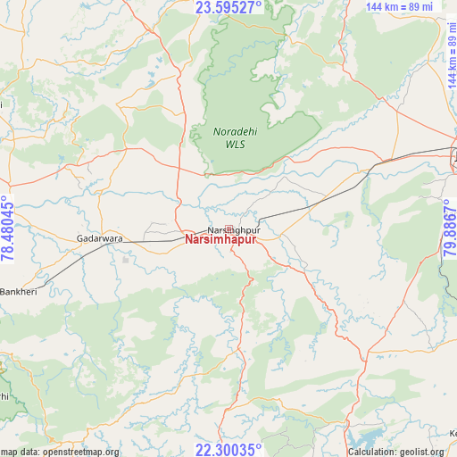
Narsimhapur GPS coordinates[2]
22° 56' 57.696" North, 79° 11' 0.852" East
| Map corner | latitude | longitude |
|---|---|---|
| Upper-left | 23.59527°, | 78.48045° |
| Center: | 22.94936°, | 79.18357° |
| Lower-right: | 22.30035°, | 79.8867° |
| Map W x H: | 144×144 km | = 89.5×89.5mi |
| max Lat: | 34.9274° ⇑48.8% North |
| Narsimhapur: | 22.94936° |
| min Lat: | ⇓51.2% South 8.09008° |
| min Long | Narsimhapur | max Long |
| 68.82655° | 79.18357° | 96.81° |
| W 60.9%⇐ | ⇒39.1% E |
Elevation
Elevation of Narsimhapur is 357 m = 1171 ft, and this is 61.4 m = 201 ft above average elevation for this country.
| Max E: |
3681 m = 12077 ft | 27.4% |
| Narsimhapur | 357 m 1171 ft | |
| Avg. | 295.6 m = 970 ft | |
Min E: |
1 m = 3 ft | 72.6% |
See also: Narsimhapur elevation on elevation.city.
Geographical zone
Narsimhapur is located in North Torrid zone (between Equator and Tropic of Cancer). Distance of this Northern Tropic circle is 54.2 km =33.7 mi to North.| Distance of | km | miles | from Narsimhapur |
|---|---|---|---|
| North Pole | 7455.3 | 4632.5 | to North |
| Arctic Circle | 4849.4 | 3013.3 | to North |
| Tropic Cancer | 54.2 | 33.7 | to North |
| Equator | 2551.7 | 1585.6 | to South |


Nearby cities:
15 places around Narsimhapur: (largest is in red/bold)
• Amarwāra
72.5 km =45 mi,  181°
181°
• Bargi
71 km =44.1 mi,  86°
86°
• Chichli
38.8 km =24.1 mi,  250°
250°
• Deori Khās
51.9 km =32.2 mi,  340°
340°
• Gādarwāra
40.9 km =25.4 mi,  265°
265°
• Harrai
37.5 km =23.3 mi,  173°
173°
• Jaithāri
64.9 km =40.3 mi,  296°
296°
• Kaimori
75 km =46.6 mi,  49°
49°
• Kareli
12.8 km =8 mi, 252°
• Lakhnādon
57.8 km =35.9 mi,  132°
132°
• Pātan
63.9 km =39.7 mi, 54°
• Rehli
77.5 km =48.2 mi,  350°
350°
• Shāhpura
53.4 km =33.2 mi,  67°
67°
• Tendūkheda
61.6 km =38.3 mi,  36°
36°
• Udaipura
70.2 km =43.6 mi,  281°
281°
Sources, notices
• [Note1] Compared only with cities in India existing in our database
• [Src1] Map data: © OpenStreetMap contributors (CC-BY-SA)
• [Src2] Other city data from geonames.org with taken over terms of usage.
• [Src3] Geographical zone / Annual Mean Temperature by Robert A. Rohde @ Wikipedia
