Udaipura geodata
Udaipura (Madhya Pradesh) is a populated place; located in India in Asia/Kolkata (GMT+5.5) time zone. With population of 15,473 people, there are 2417 cities with bigger population in this country. Compared to other cities in India, 52.1% of cities are located further ↓South; 54.2% of cities are located further ←West and 69.7% of cities have lower elevation than Udaipura. Note1


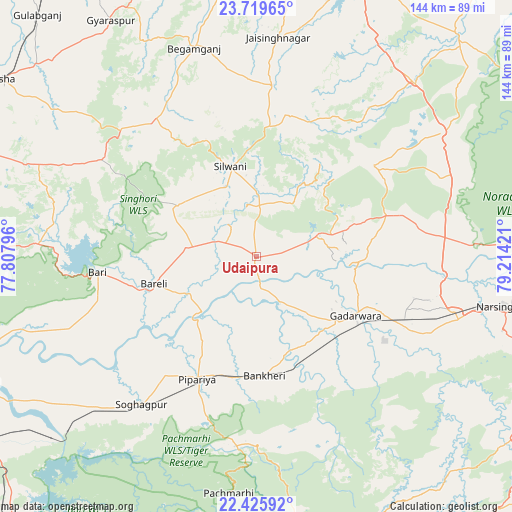
Udaipura GPS coordinates[2]
23° 4' 27.624" North, 78° 30' 39.888" East
| Map corner | latitude | longitude |
|---|---|---|
| Upper-left | 23.71965°, | 77.80796° |
| Center: | 23.07434°, | 78.51108° |
| Lower-right: | 22.42592°, | 79.21421° |
| Map W x H: | 143.8×143.9 km | = 89.4×89.4mi |
| max Lat: | 34.9274° ⇑47.9% North |
| Udaipura: | 23.07434° |
| min Lat: | ⇓52.1% South 8.09008° |
| min Long | Udaipura | max Long |
| 68.82655° | 78.51108° | 96.81° |
| W 54.2%⇐ | ⇒45.8% E |
Elevation
Elevation of Udaipura is 325 m = 1066 ft, and this is 29.4 m = 96 ft above average elevation for this country.
| Max E: |
3681 m = 12077 ft | 30.3% |
| Udaipura | 325 m 1066 ft | |
| Avg. | 295.6 m = 970 ft | |
Min E: |
1 m = 3 ft | 69.7% |
See also: India elevation on elevation.city.
Geographical zone
Udaipura is located in North Torrid zone (between Equator and Tropic of Cancer). Distance of this Northern Tropic circle is 40.3 km =25 mi to North.| Distance of | km | miles | from Udaipura |
|---|---|---|---|
| North Pole | 7441.4 | 4623.9 | to North |
| Arctic Circle | 4835.5 | 3004.6 | to North |
| Tropic Cancer | 40.3 | 25 | to North |
| Equator | 2565.6 | 1594.2 | to South |


Nearby cities:
15 places around Udaipura: (largest is in red/bold)
• Begamganj
60.9 km =37.8 mi,  343°
343°
• Bābai
72.1 km =44.8 mi,  234°
234°
• Chichli
41.9 km =26 mi,  129°
129°
• Deori Khās
62.4 km =38.8 mi,  55°
55°
• Dhāna
82.9 km =51.5 mi,  25°
25°
• Gādarwāra
32.7 km =20.3 mi,  120°
120°
• Jaithāri
18.3 km =11.4 mi,  35°
35°
• Kareli
59.3 km =36.8 mi,  107°
107°
• Narsimhapur
70.2 km =43.6 mi,  101°
101°
• Pachmarhi
67.9 km =42.2 mi,  186°
186°
• Raisen
79.8 km =49.6 mi,  290°
290°
• Rehli
84.2 km =52.3 mi, 41°
• Rāhatgarh
80.4 km =50 mi,  351°
351°
• Sohāgpur
52.7 km =32.7 mi,  217°
217°
• Sultānpur
59.4 km =36.9 mi,  276°
276°
Sources, notices
• [Note1] Compared only with cities in India existing in our database
• [Src1] Map data: © OpenStreetMap contributors (CC-BY-SA)
• [Src2] Other city data from geonames.org with taken over terms of usage.
• [Src3] Geographical zone / Annual Mean Temperature by Robert A. Rohde @ Wikipedia
