Harrai geodata
Harrai (Madhya Pradesh) is a populated place; located in India in Asia/Kolkata (GMT+5.5) time zone. With population of 10,250 people, there are 2915 cities with bigger population in this country. Compared to other cities in India, 52% of cities are located further ↑North; 61.2% of cities are located further ←West and 88.4% of cities have lower elevation than Harrai. Note1


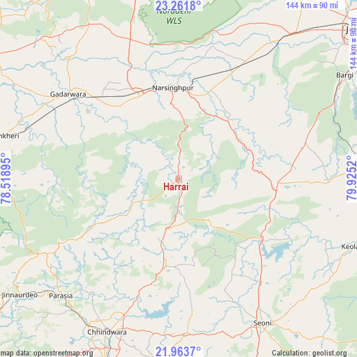
Harrai GPS coordinates[2]
22° 36' 51.408" North, 79° 13' 19.452" East
| Map corner | latitude | longitude |
|---|---|---|
| Upper-left | 23.2618°, | 78.51895° |
| Center: | 22.61428°, | 79.22207° |
| Lower-right: | 21.9637°, | 79.9252° |
| Map W x H: | 144.3×144.3 km | = 89.7×89.7mi |
| max Lat: | 34.9274° ⇑52% North |
| Harrai: | 22.61428° |
| min Lat: | ⇓48% South 8.09008° |
| min Long | Harrai | max Long |
| 68.82655° | 79.22207° | 96.81° |
| W 61.2%⇐ | ⇒38.8% E |
Elevation
Elevation of Harrai is 598 m = 1962 ft, and this is 302.4 m = 992 ft above average elevation for this country.
| Max E: |
3681 m = 12077 ft | 11.6% |
| Harrai | 598 m 1962 ft | |
| Avg. | 295.6 m = 970 ft | |
Min E: |
1 m = 3 ft | 88.4% |
See also: India elevation on elevation.city.
Geographical zone
Harrai is located in North Torrid zone (between Equator and Tropic of Cancer). Distance of this Northern Tropic circle is 91.4 km =56.8 mi to North.| Distance of | km | miles | from Harrai |
|---|---|---|---|
| North Pole | 7492.6 | 4655.7 | to North |
| Arctic Circle | 4886.7 | 3036.5 | to North |
| Tropic Cancer | 91.4 | 56.8 | to North |
| Equator | 2514.5 | 1562.4 | to South |


Nearby cities:
15 places around Harrai: (largest is in red/bold)
• Amarwāra
35.6 km =22.1 mi,  188°
188°
• Bargi
79 km =49.1 mi,  57°
57°
• Chhindwāra
68.4 km =42.5 mi,  205°
205°
• Chichli
47.4 km =29.5 mi,  300°
300°
• Ghansor
74.9 km =46.5 mi,  86°
86°
• Gādarwāra
56.5 km =35.1 mi,  307°
307°
• Jāmai
79.7 km =49.5 mi,  234°
234°
• Kareli
37.2 km =23.1 mi,  334°
334°
• Lakhnādon
38.9 km =24.2 mi, 92°
• Narsimhapur
37.5 km =23.3 mi,  353°
353°
• Pachmarhi
82.6 km =51.3 mi,  258°
258°
• Panara
82.6 km =51.3 mi,  236°
236°
• Parāsia
66.9 km =41.6 mi, 225°
• Seoni
67.8 km =42.1 mi,  150°
150°
• Shāhpura
73.6 km =45.7 mi,  37°
37°
Sources, notices
• [Note1] Compared only with cities in India existing in our database
• [Src1] Map data: © OpenStreetMap contributors (CC-BY-SA)
• [Src2] Other city data from geonames.org with taken over terms of usage.
• [Src3] Geographical zone / Annual Mean Temperature by Robert A. Rohde @ Wikipedia
