Amarwāra geodata
Amarwāra (Madhya Pradesh) is a populated place; located in India in Asia/Kolkata (GMT+5.5) time zone. With population of 13,258 people, there are 2630 cities with bigger population in this country. Compared to other cities in India, 54.5% of cities are located further ↑North; 60.6% of cities are located further ←West and 94.1% of cities have lower elevation than Amarwāra. Note1


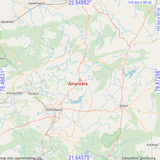
Amarwāra GPS coordinates[2]
22° 17' 52.08" North, 79° 10' 9.948" East
| Map corner | latitude | longitude |
|---|---|---|
| Upper-left | 22.94682°, | 78.46631° |
| Center: | 22.2978°, | 79.16943° |
| Lower-right: | 21.64575°, | 79.87256° |
| Map W x H: | 144.7×144.7 km | = 89.9×89.9mi |
| max Lat: | 34.9274° ⇑54.5% North |
| Amarwāra: | 22.2978° |
| min Lat: | ⇓45.5% South 8.09008° |
| min Long | Amarwāra | max Long |
| 68.82655° | 79.16943° | 96.81° |
| W 60.6%⇐ | ⇒39.4% E |
Elevation
Elevation of Amarwāra is 807 m = 2648 ft, and this is 511.4 m = 1678 ft above average elevation for this country.
| Max E: |
3681 m = 12077 ft | 5.9% |
| Amarwāra | 807 m 2648 ft | |
| Avg. | 295.6 m = 970 ft | |
Min E: |
1 m = 3 ft | 94.1% |
See also: India elevation on elevation.city.
Geographical zone
Amarwāra is located in North Torrid zone (between Equator and Tropic of Cancer). Distance of this Northern Tropic circle is 126.6 km =78.7 mi to North.| Distance of | km | miles | from Amarwāra |
|---|---|---|---|
| North Pole | 7527.8 | 4677.6 | to North |
| Arctic Circle | 4921.9 | 3058.3 | to North |
| Tropic Cancer | 126.6 | 78.7 | to North |
| Equator | 2479.3 | 1540.6 | to South |


Nearby cities:
15 places around Amarwāra: (largest is in red/bold)
• Barghāt
65.2 km =40.5 mi,  117°
117°
• Chhindwāra
35.7 km =22.2 mi,  221°
221°
• Chichli
69.2 km =43 mi,  329°
329°
• Gādarwāra
80 km =49.7 mi, 330°
• Harrai
35.6 km =22.1 mi,  8°
8°
• Jāmai
60.5 km =37.6 mi,  259°
259°
• Kareli
69.5 km =43.2 mi,  351°
351°
• Lakhnādon
55.7 km =34.6 mi,  52°
52°
• Lodhīkheda
85.7 km =53.3 mi,  201°
201°
• Narsimhapur
72.5 km =45 mi,  1°
1°
• Pachmarhi
78 km =48.5 mi,  284°
284°
• Panara
64.5 km =40.1 mi, 260°
• Parāsia
43.9 km =27.3 mi,  254°
254°
• Sausar
81.1 km =50.4 mi,  208°
208°
• Seoni
45.8 km =28.5 mi, 121°
Sources, notices
• [Note1] Compared only with cities in India existing in our database
• [Src1] Map data: © OpenStreetMap contributors (CC-BY-SA)
• [Src2] Other city data from geonames.org with taken over terms of usage.
• [Src3] Geographical zone / Annual Mean Temperature by Robert A. Rohde @ Wikipedia
