Chichli geodata
Chichli (Madhya Pradesh) is a populated place; located in India in Asia/Kolkata (GMT+5.5) time zone. With population of 10,225 people, there are 2919 cities with bigger population in this country. Compared to other cities in India, 50.4% of cities are located further ↓South; 57.3% of cities are located further ←West and 71.7% of cities have lower elevation than Chichli. Note1


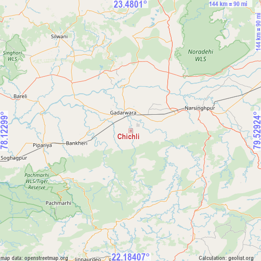
Chichli GPS coordinates[2]
22° 50' 1.068" North, 78° 49' 33.996" East
| Map corner | latitude | longitude |
|---|---|---|
| Upper-left | 23.4801°, | 78.12299° |
| Center: | 22.83363°, | 78.82611° |
| Lower-right: | 22.18407°, | 79.52924° |
| Map W x H: | 144.1×144.1 km | = 89.5×89.5mi |
| max Lat: | 34.9274° ⇑49.6% North |
| Chichli: | 22.83363° |
| min Lat: | ⇓50.4% South 8.09008° |
| min Long | Chichli | max Long |
| 68.82655° | 78.82611° | 96.81° |
| W 57.3%⇐ | ⇒42.7% E |
Elevation
Elevation of Chichli is 346 m = 1135 ft, and this is 50.4 m = 165 ft above average elevation for this country.
| Max E: |
3681 m = 12077 ft | 28.3% |
| Chichli | 346 m 1135 ft | |
| Avg. | 295.6 m = 970 ft | |
Min E: |
1 m = 3 ft | 71.7% |
See also: India elevation on elevation.city.
Geographical zone
Chichli is located in North Torrid zone (between Equator and Tropic of Cancer). Distance of this Northern Tropic circle is 67.1 km =41.7 mi to North.| Distance of | km | miles | from Chichli |
|---|---|---|---|
| North Pole | 7468.2 | 4640.5 | to North |
| Arctic Circle | 4862.3 | 3021.3 | to North |
| Tropic Cancer | 67.1 | 41.7 | to North |
| Equator | 2538.9 | 1577.6 | to South |


Nearby cities:
15 places around Chichli: (largest is in red/bold)
• Amarwāra
69.2 km =43 mi,  149°
149°
• Chhindwāra
87.1 km =54.1 mi,  172°
172°
• Deori Khās
64.9 km =40.3 mi,  17°
17°
• Gādarwāra
10.8 km =6.7 mi,  337°
337°
• Harrai
47.4 km =29.5 mi,  120°
120°
• Jaithāri
47 km =29.2 mi,  332°
332°
• Jāmai
74.8 km =46.5 mi,  198°
198°
• Kareli
26 km =16.2 mi,  69°
69°
• Lakhnādon
83.6 km =51.9 mi,  108°
108°
• Narsimhapur
38.8 km =24.1 mi, 70°
• Pachmarhi
57.3 km =35.6 mi,  224°
224°
• Panara
75.3 km =46.8 mi, 202°
• Parāsia
71.8 km =44.6 mi,  185°
185°
• Sohāgpur
66.4 km =41.3 mi,  257°
257°
• Udaipura
41.9 km =26 mi,  309°
309°
Sources, notices
• [Note1] Compared only with cities in India existing in our database
• [Src1] Map data: © OpenStreetMap contributors (CC-BY-SA)
• [Src2] Other city data from geonames.org with taken over terms of usage.
• [Src3] Geographical zone / Annual Mean Temperature by Robert A. Rohde @ Wikipedia
