Narāyangarh geodata
Narāyangarh (Haryana) is a populated place; located in India in Asia/Kolkata (GMT+5.5) time zone. With population of 20,085 people, there are 2037 cities with bigger population in this country. Compared to other cities in India, 94.3% of cities are located further ↓South; 61.7% of cities are located further →East and 70.5% of cities have lower elevation than Narāyangarh. Note1


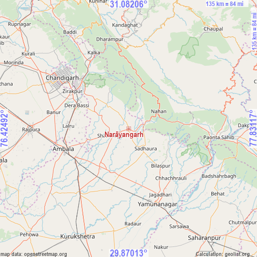
Narāyangarh GPS coordinates[2]
30° 28' 40.728" North, 77° 7' 40.944" East
| Map corner | latitude | longitude |
|---|---|---|
| Upper-left | 31.08206°, | 76.42492° |
| Center: | 30.47798°, | 77.12804° |
| Lower-right: | 29.87013°, | 77.83117° |
| Map W x H: | 134.8×134.8 km | = 83.8×83.8mi |
| max Lat: | 34.9274° ⇑5.7% North |
| Narāyangarh: | 30.47798° |
| min Lat: | ⇓94.3% South 8.09008° |
| min Long | Narāyangarh | max Long |
| 68.82655° | 77.12804° | 96.81° |
| W 38.3%⇐ | ⇒61.7% E |
Elevation
Elevation of Narāyangarh is 332 m = 1089 ft, and this is 36.4 m = 119 ft above average elevation for this country.
| Max E: |
3681 m = 12077 ft | 29.5% |
| Narāyangarh | 332 m 1089 ft | |
| Avg. | 295.6 m = 970 ft | |
Min E: |
1 m = 3 ft | 70.5% |
See also: India elevation on elevation.city.
Geographical zone
Narāyangarh is located in North temperate zone (between Tropic of Cancer and the Arctic Circle). Distance of this Northern Tropic circle is 782.9 km =486.5 mi to South.| Distance of | km | miles | from Narāyangarh |
|---|---|---|---|
| North Pole | 6618.2 | 4112.4 | to North |
| Arctic Circle | 4012.3 | 2493.1 | to North |
| Tropic Cancer | 782.9 | 486.5 | to South |
| Equator | 3388.8 | 2105.7 | to South |


Nearby cities:
15 places around Narāyangarh: (largest is in red/bold)
• Ambāla
34.2 km =21.3 mi,  247°
247°
• Banūr
40 km =24.9 mi,  282°
282°
• Basi
29.7 km =18.5 mi,  294°
294°
• Bilāspur
25.6 km =15.9 mi,  138°
138°
• Būriya
41.8 km =26 mi,  148°
148°
• Chandigarh
43.4 km =27 mi,  311°
311°
• Chhachhrauli
34.2 km =21.3 mi, 139°
• Jagādhri
38.4 km =23.9 mi, 153°
• Mustafābād
30.7 km =19.1 mi,  176°
176°
• Nāhan
18.4 km =11.4 mi,  60°
60°
• Panchkula
35.9 km =22.3 mi, 312°
• Parwanoo
43 km =26.7 mi,  338°
338°
• Pinjaur
40.9 km =25.4 mi,  330°
330°
• Shāhābād
42.4 km =26.3 mi,  215°
215°
• Yamunānagar
41.7 km =25.9 mi,  158°
158°
Sources, notices
• [Note1] Compared only with cities in India existing in our database
• [Src1] Map data: © OpenStreetMap contributors (CC-BY-SA)
• [Src2] Other city data from geonames.org with taken over terms of usage.
• [Src3] Geographical zone / Annual Mean Temperature by Robert A. Rohde @ Wikipedia
