Farīdnagar geodata
Farīdnagar (Uttar Pradesh) is a populated place; located in India in Asia/Kolkata (GMT+5.5) time zone. With population of 11,371 people, there are 2796 cities with bigger population in this country. Compared to other cities in India, 88.1% of cities are located further ↓South; 55.7% of cities are located further →East and 53.3% of cities have lower elevation than Farīdnagar. Note1


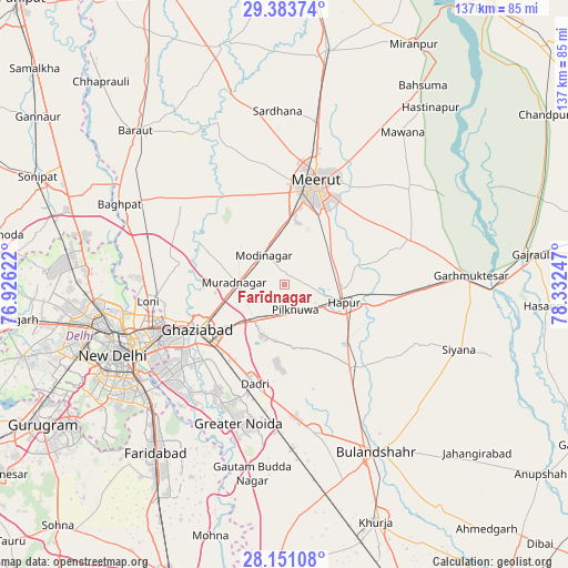
Farīdnagar GPS coordinates[2]
28° 46' 9.228" North, 77° 37' 45.624" East
| Map corner | latitude | longitude |
|---|---|---|
| Upper-left | 29.38374°, | 76.92622° |
| Center: | 28.76923°, | 77.62934° |
| Lower-right: | 28.15108°, | 78.33247° |
| Map W x H: | 137.1×137.1 km | = 85.2×85.2mi |
| max Lat: | 34.9274° ⇑11.9% North |
| Farīdnagar: | 28.76923° |
| min Lat: | ⇓88.1% South 8.09008° |
| min Long | Farīdnagar | max Long |
| 68.82655° | 77.62934° | 96.81° |
| W 44.3%⇐ | ⇒55.7% E |
Elevation
Elevation of Farīdnagar is 219 m = 719 ft, and this is 76.6 m = 251 ft below average elevation for this country.
| Max E: |
3681 m = 12077 ft | 46.7% |
| Avg. | 295.6 m = 970 ft | |
| Farīdnagar | 219 m = 719 ft | |
Min E: |
1 m = 3 ft | 53.3% |
See also: India elevation on elevation.city.
Geographical zone
Farīdnagar is located in North temperate zone (between Tropic of Cancer and the Arctic Circle). Distance of this Northern Tropic circle is 592.9 km =368.4 mi to South.| Distance of | km | miles | from Farīdnagar |
|---|---|---|---|
| North Pole | 6808.2 | 4230.4 | to North |
| Arctic Circle | 4202.3 | 2611.2 | to North |
| Tropic Cancer | 592.9 | 368.4 | to South |
| Equator | 3198.8 | 1987.6 | to South |


Nearby cities:
15 places around Farīdnagar: (largest is in red/bold)
• Babugarh
21.8 km =13.5 mi,  103°
103°
• Dādri
25.2 km =15.7 mi,  196°
196°
• Dāsna
14.6 km =9.1 mi,  225°
225°
• Ghāziābād
21.8 km =13.5 mi,  238°
238°
• Greater Noida
31.7 km =19.7 mi, 196°
• Gulāothi
25.6 km =15.9 mi,  141°
141°
• Hāpur
15.4 km =9.6 mi,  106°
106°
• Kharkhauda
13.2 km =8.2 mi,  55°
55°
• Kithor
32 km =19.9 mi,  70°
70°
• Loni
33.1 km =20.6 mi,  266°
266°
• Meerut
24.6 km =15.3 mi,  17°
17°
• Murādnagar
12.8 km =8 mi,  275°
275°
• Niwāri
14.8 km =9.2 mi,  323°
323°
• Pilkhua
6.8 km =4.2 mi,  157°
157°
• Saidpur
32.5 km =20.2 mi,  122°
122°
Sources, notices
• [Note1] Compared only with cities in India existing in our database
• [Src1] Map data: © OpenStreetMap contributors (CC-BY-SA)
• [Src2] Other city data from geonames.org with taken over terms of usage.
• [Src3] Geographical zone / Annual Mean Temperature by Robert A. Rohde @ Wikipedia
