Pilkhua geodata
Pilkhua (Uttar Pradesh) is a populated place; located in India in Asia/Kolkata (GMT+5.5) time zone. With population of 74,212 people, there are 590 cities with bigger population in this country. Compared to other cities in India, 87.9% of cities are located further ↓South; 55.5% of cities are located further →East and 53.6% of cities have lower elevation than Pilkhua. Note1


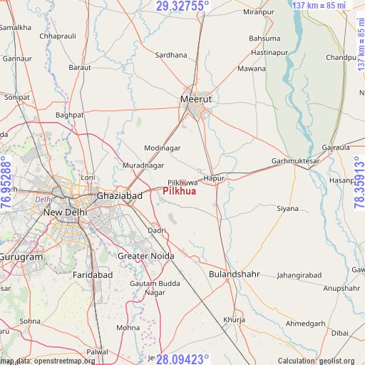
Pilkhua GPS coordinates[2]
28° 42' 45.756" North, 77° 39' 21.6" East
| Map corner | latitude | longitude |
|---|---|---|
| Upper-left | 29.32755°, | 76.95288° |
| Center: | 28.71271°, | 77.656° |
| Lower-right: | 28.09423°, | 78.35913° |
| Map W x H: | 137.1×137.1 km | = 85.2×85.2mi |
| max Lat: | 34.9274° ⇑12.1% North |
| Pilkhua: | 28.71271° |
| min Lat: | ⇓87.9% South 8.09008° |
| min Long | Pilkhua | max Long |
| 68.82655° | 77.656° | 96.81° |
| W 44.5%⇐ | ⇒55.5% E |
Elevation
Elevation of Pilkhua is 220 m = 722 ft, and this is 75.6 m = 248 ft below average elevation for this country.
| Max E: |
3681 m = 12077 ft | 46.4% |
| Avg. | 295.6 m = 970 ft | |
| Pilkhua | 220 m = 722 ft | |
Min E: |
1 m = 3 ft | 53.6% |
See also: Pilkhua elevation on elevation.city.
Geographical zone
Pilkhua is located in North temperate zone (between Tropic of Cancer and the Arctic Circle). Distance of this Northern Tropic circle is 586.6 km =364.5 mi to South.| Distance of | km | miles | from Pilkhua |
|---|---|---|---|
| North Pole | 6814.5 | 4234.3 | to North |
| Arctic Circle | 4208.6 | 2615.1 | to North |
| Tropic Cancer | 586.6 | 364.5 | to South |
| Equator | 3192.6 | 1983.8 | to South |


Nearby cities:
15 places around Pilkhua: (largest is in red/bold)
• Babugarh
18.6 km =11.6 mi,  86°
86°
• Dādri
20.4 km =12.7 mi,  209°
209°
• Dāsna
13.6 km =8.5 mi,  253°
253°
• Farīdnagar
6.8 km =4.2 mi,  337°
337°
• Ghāziābād
21.8 km =13.5 mi,  256°
256°
• Greater Noida
26.8 km =16.7 mi, 205°
• Gulāothi
19.2 km =11.9 mi,  135°
135°
• Hāpur
12.3 km =7.6 mi,  81°
81°
• Kharkhauda
16.1 km =10 mi,  31°
31°
• Kithor
32.4 km =20.1 mi,  58°
58°
• Meerut
30.1 km =18.7 mi,  9°
9°
• Murādnagar
17.1 km =10.6 mi,  296°
296°
• Niwāri
21.5 km =13.4 mi,  327°
327°
• Saidpur
27.2 km =16.9 mi,  114°
114°
• Sikandarābād
29.3 km =18.2 mi,  171°
171°
Sources, notices
• [Note1] Compared only with cities in India existing in our database
• [Src1] Map data: © OpenStreetMap contributors (CC-BY-SA)
• [Src2] Other city data from geonames.org with taken over terms of usage.
• [Src3] Geographical zone / Annual Mean Temperature by Robert A. Rohde @ Wikipedia
