Hungund geodata
Hungund (Karnataka) is a populated place; located in India in Asia/Kolkata (GMT+5.5) time zone. With population of 19,036 people, there are 2120 cities with bigger population in this country. Compared to other cities in India, 77.8% of cities are located further ↑North; 73% of cities are located further →East and 84.3% of cities have lower elevation than Hungund. Note1


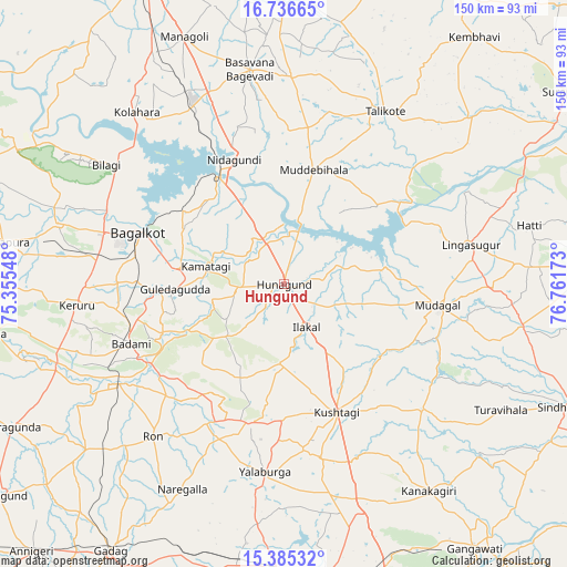
Hungund GPS coordinates[2]
16° 3' 43.668" North, 76° 3' 30.96" East
| Map corner | latitude | longitude |
|---|---|---|
| Upper-left | 16.73665°, | 75.35548° |
| Center: | 16.06213°, | 76.0586° |
| Lower-right: | 15.38532°, | 76.76173° |
| Map W x H: | 150.3×150.3 km | = 93.4×93.4mi |
| max Lat: | 34.9274° ⇑77.8% North |
| Hungund: | 16.06213° |
| min Lat: | ⇓22.2% South 8.09008° |
| min Long | Hungund | max Long |
| 68.82655° | 76.0586° | 96.81° |
| W 27%⇐ | ⇒73% E |
Elevation
Elevation of Hungund is 539 m = 1768 ft, and this is 243.4 m = 799 ft above average elevation for this country.
| Max E: |
3681 m = 12077 ft | 15.7% |
| Hungund | 539 m 1768 ft | |
| Avg. | 295.6 m = 970 ft | |
Min E: |
1 m = 3 ft | 84.3% |
See also: India elevation on elevation.city.
Geographical zone
Hungund is located in North Torrid zone (between Equator and Tropic of Cancer). Distance of this Northern Tropic circle is 820 km =509.5 mi to North.| Distance of | km | miles | from Hungund |
|---|---|---|---|
| North Pole | 8221.1 | 5108.4 | to North |
| Arctic Circle | 5615.2 | 3489.1 | to North |
| Tropic Cancer | 820 | 509.5 | to North |
| Equator | 1785.9 | 1109.7 | to South |


Nearby cities:
15 places around Hungund: (largest is in red/bold)
• Bagalkot
41.1 km =25.5 mi,  289°
289°
• Basavana Bāgevādi
57.5 km =35.7 mi,  350°
350°
• Bilgi
56.7 km =35.2 mi,  303°
303°
• Bādāmi
44 km =27.3 mi,  248°
248°
• Gajendragarh
37.5 km =23.3 mi,  194°
194°
• Guledagudda
28.7 km =17.8 mi,  267°
267°
• Ilkal
12.9 km =8 mi,  152°
152°
• Kerūr
55 km =34.2 mi,  264°
264°
• Kushtagi
36.8 km =22.9 mi,  157°
157°
• Lingsugūr
50.6 km =31.4 mi,  77°
77°
• Muddebihāl
31.6 km =19.6 mi,  14°
14°
• Mudgal
41.4 km =25.7 mi,  97°
97°
• Ron
53.2 km =33.1 mi,  220°
220°
• Tālīkota
53 km =32.9 mi,  30°
30°
• Yelbarga
49.9 km =31 mi, 185°
Sources, notices
• [Note1] Compared only with cities in India existing in our database
• [Src1] Map data: © OpenStreetMap contributors (CC-BY-SA)
• [Src2] Other city data from geonames.org with taken over terms of usage.
• [Src3] Geographical zone / Annual Mean Temperature by Robert A. Rohde @ Wikipedia
