Mokokchūng geodata
Mokokchūng (Nagaland) is a populated place; located in India in Asia/Kolkata (GMT+5.5) time zone. With population of 34,021 people, there are 1279 cities with bigger population in this country. Compared to other cities in India, 73.2% of cities are located further ↓South; 99.1% of cities are located further ←West and 97% of cities have lower elevation than Mokokchūng. Note1


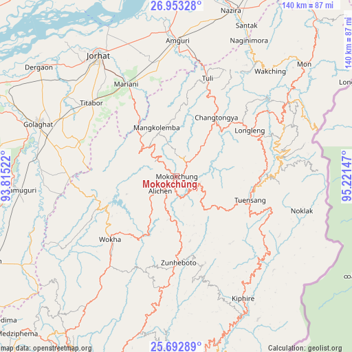
Mokokchūng GPS coordinates[2]
26° 19' 29.28" North, 94° 31' 6.024" East
| Map corner | latitude | longitude |
|---|---|---|
| Upper-left | 26.95328°, | 93.81522° |
| Center: | 26.3248°, | 94.51834° |
| Lower-right: | 25.69289°, | 95.22147° |
| Map W x H: | 140.1×140.1 km | = 87.1×87.1mi |
| max Lat: | 34.9274° ⇑26.8% North |
| Mokokchūng: | 26.3248° |
| min Lat: | ⇓73.2% South 8.09008° |
| min Long | Mokokchūng | max Long |
| 68.82655° | 94.51834° | 96.81° |
| W 99.1%⇐ | ⇒0.90000000000001% E |
Elevation
Elevation of Mokokchūng is 1250 m = 4101 ft, and this is 954.4 m = 3131 ft above average elevation for this country.
| Max E: |
3681 m = 12077 ft | 3% |
| Mokokchūng | 1250 m 4101 ft | |
| Avg. | 295.6 m = 970 ft | |
Min E: |
1 m = 3 ft | 97% |
See also: India elevation on elevation.city.
Geographical zone
Mokokchūng is located in North temperate zone (between Tropic of Cancer and the Arctic Circle). Distance of this Northern Tropic circle is 321.1 km =199.5 mi to South.| Distance of | km | miles | from Mokokchūng |
|---|---|---|---|
| North Pole | 7080 | 4399.3 | to North |
| Arctic Circle | 4474.1 | 2780.1 | to North |
| Tropic Cancer | 321.1 | 199.5 | to South |
| Equator | 2927 | 1818.8 | to South |


Nearby cities:
15 places around Mokokchūng: (largest is in red/bold)
• Amguri
54.5 km =33.9 mi,  0°
0°
• Barpathār
62.9 km =39.1 mi,  266°
266°
• Dergaon
68.9 km =42.8 mi,  307°
307°
• Golāghāt
59.4 km =36.9 mi,  290°
290°
• Jorhāt
57.4 km =35.7 mi,  326°
326°
• Longleng
35 km =21.7 mi,  58°
58°
• Mariāni
42.1 km =26.2 mi, 331°
• Mon
70.5 km =43.8 mi,  49°
49°
• Nāzirā
69.3 km =43.1 mi,  18°
18°
• Phek
73.2 km =45.5 mi,  181°
181°
• Sibsāgar
74.3 km =46.2 mi,  9°
9°
• Titābar
43.9 km =27.3 mi, 314°
• Tuensang
31.2 km =19.4 mi,  101°
101°
• Wokha
36.3 km =22.6 mi,  225°
225°
• Zunheboto
39.8 km =24.7 mi, 180°
Sources, notices
• [Note1] Compared only with cities in India existing in our database
• [Src1] Map data: © OpenStreetMap contributors (CC-BY-SA)
• [Src2] Other city data from geonames.org with taken over terms of usage.
• [Src3] Geographical zone / Annual Mean Temperature by Robert A. Rohde @ Wikipedia
