Wokha geodata
Wokha (Nagaland) is a populated place; located in India in Asia/Kolkata (GMT+5.5) time zone. With population of 54,010 people, there are 820 cities with bigger population in this country. Compared to other cities in India, 71.1% of cities are located further ↓South; 99% of cities are located further ←West and 97.5% of cities have lower elevation than Wokha. Note1


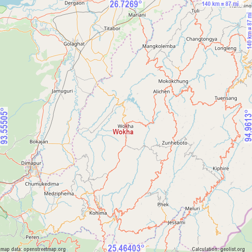
Wokha GPS coordinates[2]
26° 5' 49.812" North, 94° 15' 29.412" East
| Map corner | latitude | longitude |
|---|---|---|
| Upper-left | 26.7269°, | 93.55505° |
| Center: | 26.09717°, | 94.25817° |
| Lower-right: | 25.46403°, | 94.9613° |
| Map W x H: | 140.4×140.4 km | = 87.2×87.2mi |
| max Lat: | 34.9274° ⇑28.9% North |
| Wokha: | 26.09717° |
| min Lat: | ⇓71.1% South 8.09008° |
| min Long | Wokha | max Long |
| 68.82655° | 94.25817° | 96.81° |
| W 99%⇐ | ⇒1% E |
Elevation
Elevation of Wokha is 1385 m = 4544 ft, and this is 1089.4 m = 3574 ft above average elevation for this country.
| Max E: |
3681 m = 12077 ft | 2.5% |
| Wokha | 1385 m 4544 ft | |
| Avg. | 295.6 m = 970 ft | |
Min E: |
1 m = 3 ft | 97.5% |
See also: Wokha elevation on elevation.city.
Geographical zone
Wokha is located in North temperate zone (between Tropic of Cancer and the Arctic Circle). Distance of this Northern Tropic circle is 295.8 km =183.8 mi to South.| Distance of | km | miles | from Wokha |
|---|---|---|---|
| North Pole | 7105.3 | 4415 | to North |
| Arctic Circle | 4499.4 | 2795.8 | to North |
| Tropic Cancer | 295.8 | 183.8 | to South |
| Equator | 2901.7 | 1803 | to South |


Nearby cities:
15 places around Wokha: (largest is in red/bold)
• Barpathār
42.5 km =26.4 mi,  299°
299°
• Bokajān
48.6 km =30.2 mi,  259°
259°
• Dergaon
73 km =45.4 mi,  336°
336°
• Dimāpur
57.4 km =35.7 mi,  248°
248°
• Golāghāt
54.9 km =34.1 mi,  327°
327°
• Jorhāt
73.6 km =45.7 mi,  355°
355°
• Kohima
49.2 km =30.6 mi,  197°
197°
• Longleng
70.8 km =44 mi,  51°
51°
• Mariāni
62.5 km =38.8 mi,  5°
5°
• Mokokchūng
36.3 km =22.6 mi, 45°
• Numāligarh
79.1 km =49.2 mi,  317°
317°
• Phek
53.6 km =33.3 mi,  153°
153°
• Titābar
56.3 km =35 mi,  354°
354°
• Tuensang
59.5 km =37 mi,  71°
71°
• Zunheboto
29.6 km =18.4 mi,  119°
119°
Sources, notices
• [Note1] Compared only with cities in India existing in our database
• [Src1] Map data: © OpenStreetMap contributors (CC-BY-SA)
• [Src2] Other city data from geonames.org with taken over terms of usage.
• [Src3] Geographical zone / Annual Mean Temperature by Robert A. Rohde @ Wikipedia
