Phek geodata
Phek (Manipur) is a populated place; located in India in Asia/Kolkata (GMT+5.5) time zone. With population of 15,118 people, there are 2449 cities with bigger population in this country. Compared to other cities in India, 68.2% of cities are located further ↓South; 99% of cities are located further ←West and 98.8% of cities have lower elevation than Phek. Note1


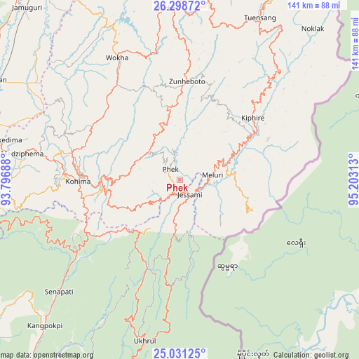
Phek GPS coordinates[2]
25° 40' 0.012" North, 94° 30' 0" East
| Map corner | latitude | longitude |
|---|---|---|
| Upper-left | 26.29872°, | 93.79688° |
| Center: | 25.66667°, | 94.5° |
| Lower-right: | 25.03125°, | 95.20313° |
| Map W x H: | 140.9×140.9 km | = 87.6×87.6mi |
| max Lat: | 34.9274° ⇑31.8% North |
| Phek: | 25.66667° |
| min Lat: | ⇓68.2% South 8.09008° |
| min Long | Phek | max Long |
| 68.82655° | 94.5° | 96.81° |
| W 99%⇐ | ⇒1% E |
Elevation
Elevation of Phek is 1696 m = 5564 ft, and this is 1400.4 m = 4594 ft above average elevation for this country.
| Max E: |
3681 m = 12077 ft | 1.2% |
| Phek | 1696 m 5564 ft | |
| Avg. | 295.6 m = 970 ft | |
Min E: |
1 m = 3 ft | 98.8% |
See also: India elevation on elevation.city.
Geographical zone
Phek is located in North temperate zone (between Tropic of Cancer and the Arctic Circle). Distance of this Northern Tropic circle is 247.9 km =154 mi to South.| Distance of | km | miles | from Phek |
|---|---|---|---|
| North Pole | 7153.2 | 4444.8 | to North |
| Arctic Circle | 4547.3 | 2825.6 | to North |
| Tropic Cancer | 247.9 | 154 | to South |
| Equator | 2853.9 | 1773.3 | to South |


Nearby cities:
15 places around Phek: (largest is in red/bold)
• Barpathār
92.2 km =57.3 mi,  318°
318°
• Bokajān
82.2 km =51.1 mi,  298°
298°
• Dimāpur
82.5 km =51.3 mi,  289°
289°
• Diphu
108.8 km =67.6 mi,  280°
280°
• Golāghāt
108.4 km =67.4 mi,  330°
330°
• Imphal
110.6 km =68.7 mi,  210°
210°
• Kamjong
89.9 km =55.9 mi,  179°
179°
• Kohima
39 km =24.2 mi,  271°
271°
• Kāngpokpi
78 km =48.5 mi,  222°
222°
• Longleng
96.9 km =60.2 mi,  19°
19°
• Mokokchūng
73.2 km =45.5 mi,  1°
1°
• Titābar
108.1 km =67.2 mi,  344°
344°
• Tuensang
74.2 km =46.1 mi,  25°
25°
• Wokha
53.6 km =33.3 mi, 333°
• Zunheboto
33.4 km =20.8 mi, 2°
Sources, notices
• [Note1] Compared only with cities in India existing in our database
• [Src1] Map data: © OpenStreetMap contributors (CC-BY-SA)
• [Src2] Other city data from geonames.org with taken over terms of usage.
• [Src3] Geographical zone / Annual Mean Temperature by Robert A. Rohde @ Wikipedia
