Maner geodata
Maner (Bihar) is a populated place; located in India in Asia/Kolkata (GMT+5.5) time zone. With population of 27,901 people, there are 1544 cities with bigger population in this country. Compared to other cities in India, 68.1% of cities are located further ↓South; 84% of cities are located further ←West and 75.2% of cities have higher elevation than Maner. Note1


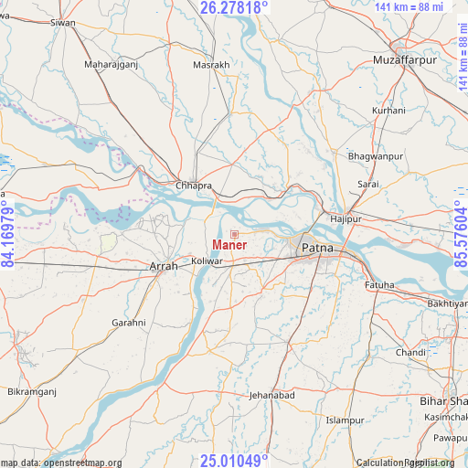
Maner GPS coordinates[2]
25° 38' 45.672" North, 84° 52' 22.476" East
| Map corner | latitude | longitude |
|---|---|---|
| Upper-left | 26.27818°, | 84.16979° |
| Center: | 25.64602°, | 84.87291° |
| Lower-right: | 25.01049°, | 85.57604° |
| Map W x H: | 141×141 km | = 87.6×87.6mi |
| max Lat: | 34.9274° ⇑31.9% North |
| Maner: | 25.64602° |
| min Lat: | ⇓68.1% South 8.09008° |
| min Long | Maner | max Long |
| 68.82655° | 84.87291° | 96.81° |
| W 84%⇐ | ⇒16% E |
Elevation
Elevation of Maner is 67 m = 220 ft, and this is 228.6 m = 750 ft below average elevation for this country.
| Max E: |
3681 m = 12077 ft | 75.2% |
| Avg. | 295.6 m = 970 ft | |
| Maner | 67 m = 220 ft | |
Min E: |
1 m = 3 ft | 24.8% |
See also: India elevation on elevation.city.
Geographical zone
Maner is located in North temperate zone (between Tropic of Cancer and the Arctic Circle). Distance of this Northern Tropic circle is 245.7 km =152.7 mi to South.| Distance of | km | miles | from Maner |
|---|---|---|---|
| North Pole | 7155.5 | 4446.2 | to North |
| Arctic Circle | 4549.6 | 2827 | to North |
| Tropic Cancer | 245.7 | 152.7 | to South |
| Equator | 2851.6 | 1771.9 | to South |


Nearby cities:
15 places around Maner: (largest is in red/bold)
• Arrah
23.3 km =14.5 mi,  244°
244°
• Chāpra
19.5 km =12.1 mi,  319°
319°
• Dighwāra
17.6 km =10.9 mi,  51°
51°
• Dinapore
17.6 km =10.9 mi,  93°
93°
• Fatwa
45.9 km =28.5 mi,  109°
109°
• Hājīpur
34 km =21.1 mi,  82°
82°
• Jahānābād
49.4 km =30.7 mi,  166°
166°
• Khagaul
18.9 km =11.7 mi, 113°
• Koelwār
10.5 km =6.5 mi,  226°
226°
• Lālganj
39 km =24.2 mi, 50°
• Marhaura
36.4 km =22.6 mi,  359°
359°
• Masaurhi Buzurg
36.2 km =22.5 mi,  153°
153°
• Patna
27 km =16.8 mi,  102°
102°
• Revelganj
28.6 km =17.8 mi,  303°
303°
• Shāhpur
47.2 km =29.3 mi,  264°
264°
Sources, notices
• [Note1] Compared only with cities in India existing in our database
• [Src1] Map data: © OpenStreetMap contributors (CC-BY-SA)
• [Src2] Other city data from geonames.org with taken over terms of usage.
• [Src3] Geographical zone / Annual Mean Temperature by Robert A. Rohde @ Wikipedia
