Koelwār geodata
Koelwār (Bihar) is a populated place; located in India in Asia/Kolkata (GMT+5.5) time zone. With population of 25,494 people, there are 1668 cities with bigger population in this country. Compared to other cities in India, 67.5% of cities are located further ↓South; 83.8% of cities are located further ←West and 75.9% of cities have higher elevation than Koelwār. Note1


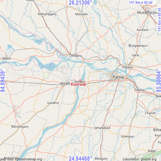
Koelwār GPS coordinates[2]
25° 34' 49.98" North, 84° 47' 51.036" East
| Map corner | latitude | longitude |
|---|---|---|
| Upper-left | 26.21306°, | 84.09439° |
| Center: | 25.58055°, | 84.79751° |
| Lower-right: | 24.94468°, | 85.50064° |
| Map W x H: | 141×141 km | = 87.6×87.6mi |
| max Lat: | 34.9274° ⇑32.5% North |
| Koelwār: | 25.58055° |
| min Lat: | ⇓67.5% South 8.09008° |
| min Long | Koelwār | max Long |
| 68.82655° | 84.79751° | 96.81° |
| W 83.8%⇐ | ⇒16.2% E |
Elevation
Elevation of Koelwār is 64 m = 210 ft, and this is 231.6 m = 760 ft below average elevation for this country.
| Max E: |
3681 m = 12077 ft | 75.9% |
| Avg. | 295.6 m = 970 ft | |
| Koelwār | 64 m = 210 ft | |
Min E: |
1 m = 3 ft | 24.1% |
See also: India elevation on elevation.city.
Geographical zone
Koelwār is located in North temperate zone (between Tropic of Cancer and the Arctic Circle). Distance of this Northern Tropic circle is 238.4 km =148.1 mi to South.| Distance of | km | miles | from Koelwār |
|---|---|---|---|
| North Pole | 7162.8 | 4450.8 | to North |
| Arctic Circle | 4556.9 | 2831.5 | to North |
| Tropic Cancer | 238.4 | 148.1 | to South |
| Equator | 2844.3 | 1767.4 | to South |


Nearby cities:
15 places around Koelwār: (largest is in red/bold)
• Arrah
13.7 km =8.5 mi,  258°
258°
• Chāpra
22.8 km =14.2 mi,  347°
347°
• Dighwāra
28 km =17.4 mi,  49°
49°
• Dinapore
25.9 km =16.1 mi,  75°
75°
• Hājīpur
42.9 km =26.7 mi,  74°
74°
• Jagdīspur
39.9 km =24.8 mi,  251°
251°
• Jahānābād
45 km =28 mi,  154°
154°
• Khagaul
24.9 km =15.5 mi,  90°
90°
• Maner
10.5 km =6.5 mi, 46°
• Marhaura
44.3 km =27.5 mi,  9°
9°
• Masaurhi Buzurg
34.5 km =21.4 mi,  136°
136°
• Patna
33.9 km =21.1 mi, 87°
• Piro
48.2 km =30 mi,  235°
235°
• Revelganj
28.3 km =17.6 mi,  325°
325°
• Shāhpur
39.5 km =24.5 mi,  273°
273°
Sources, notices
• [Note1] Compared only with cities in India existing in our database
• [Src1] Map data: © OpenStreetMap contributors (CC-BY-SA)
• [Src2] Other city data from geonames.org with taken over terms of usage.
• [Src3] Geographical zone / Annual Mean Temperature by Robert A. Rohde @ Wikipedia
