Arrah geodata
Arrah (Bihar) is a populated place; located in India in Asia/Kolkata (GMT+5.5) time zone. With population of 223,676 people, there are 191 cities with bigger population in this country. Compared to other cities in India, 67.3% of cities are located further ↓South; 83.5% of cities are located further ←West and 75.9% of cities have higher elevation than Arrah. Note1


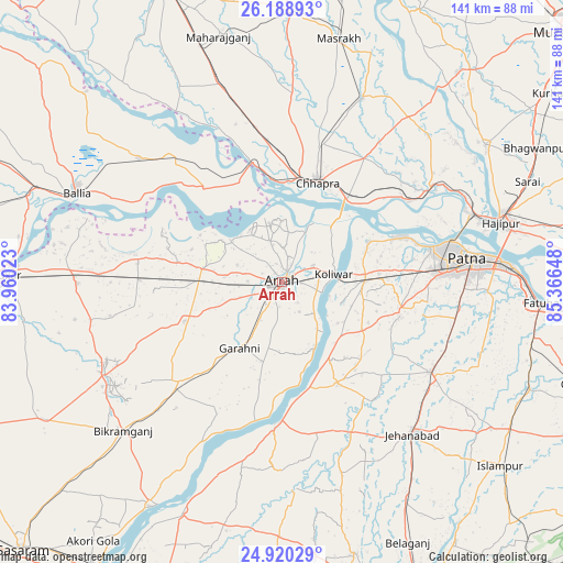
Arrah GPS coordinates[2]
25° 33' 22.644" North, 84° 39' 48.06" East
| Map corner | latitude | longitude |
|---|---|---|
| Upper-left | 26.18893°, | 83.96023° |
| Center: | 25.55629°, | 84.66335° |
| Lower-right: | 24.92029°, | 85.36648° |
| Map W x H: | 141.1×141.1 km | = 87.7×87.7mi |
| max Lat: | 34.9274° ⇑32.7% North |
| Arrah: | 25.55629° |
| min Lat: | ⇓67.3% South 8.09008° |
| min Long | Arrah | max Long |
| 68.82655° | 84.66335° | 96.81° |
| W 83.5%⇐ | ⇒16.5% E |
Elevation
Elevation of Arrah is 64 m = 210 ft, and this is 231.6 m = 760 ft below average elevation for this country.
| Max E: |
3681 m = 12077 ft | 75.9% |
| Avg. | 295.6 m = 970 ft | |
| Arrah | 64 m = 210 ft | |
Min E: |
1 m = 3 ft | 24.1% |
See also: Arrah elevation on elevation.city.
Geographical zone
Arrah is located in North temperate zone (between Tropic of Cancer and the Arctic Circle). Distance of this Northern Tropic circle is 235.7 km =146.5 mi to South.| Distance of | km | miles | from Arrah |
|---|---|---|---|
| North Pole | 7165.5 | 4452.4 | to North |
| Arctic Circle | 4559.6 | 2833.2 | to North |
| Tropic Cancer | 235.7 | 146.5 | to South |
| Equator | 2841.6 | 1765.7 | to South |


Nearby cities:
15 places around Arrah: (largest is in red/bold)
• Chāpra
26.3 km =16.3 mi,  18°
18°
• Dighwāra
40.6 km =25.2 mi,  58°
58°
• Dinapore
39.6 km =24.6 mi,  76°
76°
• Jagdīspur
26.4 km =16.4 mi,  248°
248°
• Jahānābād
50.1 km =31.1 mi,  139°
139°
• Khagaul
38.4 km =23.9 mi,  86°
86°
• Koelwār
13.7 km =8.5 mi, 78°
• Koāth
47.9 km =29.8 mi,  237°
237°
• Maner
23.3 km =14.5 mi, 64°
• Masaurhi Buzurg
43.3 km =26.9 mi,  121°
121°
• Patna
47.6 km =29.6 mi, 84°
• Piro
36 km =22.4 mi,  226°
226°
• Reoti
43.5 km =27 mi,  318°
318°
• Revelganj
26.1 km =16.2 mi,  353°
353°
• Shāhpur
26.5 km =16.5 mi,  281°
281°
Sources, notices
• [Note1] Compared only with cities in India existing in our database
• [Src1] Map data: © OpenStreetMap contributors (CC-BY-SA)
• [Src2] Other city data from geonames.org with taken over terms of usage.
• [Src3] Geographical zone / Annual Mean Temperature by Robert A. Rohde @ Wikipedia
