Imphal geodata
Imphal (Manipur) is a seat of a first-order administrative division; located in India in Asia/Kolkata (GMT+5.5) time zone. With population of 223,523 people, there are 192 cities with bigger population in this country. Compared to other cities in India, 62.4% of cities are located further ↓South; 98.5% of cities are located further ←West and 93.7% of cities have lower elevation than Imphal. Note1


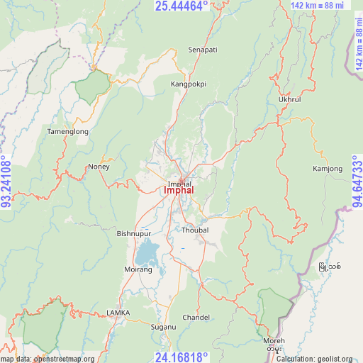
Imphal GPS coordinates[2]
24° 48' 28.98" North, 93° 56' 39.12" East
| Map corner | latitude | longitude |
|---|---|---|
| Upper-left | 25.44464°, | 93.24108° |
| Center: | 24.80805°, | 93.9442° |
| Lower-right: | 24.16818°, | 94.64733° |
| Map W x H: | 141.9×141.9 km | = 88.2×88.2mi |
| max Lat: | 34.9274° ⇑37.6% North |
| Imphal: | 24.80805° |
| min Lat: | ⇓62.4% South 8.09008° |
| min Long | Imphal | max Long |
| 68.82655° | 93.9442° | 96.81° |
| W 98.5%⇐ | ⇒1.5% E |
Elevation
Elevation of Imphal is 784 m = 2572 ft, and this is 488.4 m = 1602 ft above average elevation for this country.
| Max E: |
3681 m = 12077 ft | 6.3% |
| Imphal | 784 m 2572 ft | |
| Avg. | 295.6 m = 970 ft | |
Min E: |
1 m = 3 ft | 93.7% |
See also: Imphal elevation on elevation.city.
Geographical zone
Imphal is located in North temperate zone (between Tropic of Cancer and the Arctic Circle). Distance of this Northern Tropic circle is 152.5 km =94.8 mi to South.| Distance of | km | miles | from Imphal |
|---|---|---|---|
| North Pole | 7248.7 | 4504.1 | to North |
| Arctic Circle | 4642.8 | 2884.9 | to North |
| Tropic Cancer | 152.5 | 94.8 | to South |
| Equator | 2758.4 | 1714 | to South |


Nearby cities:
15 places around Imphal: (largest is in red/bold)
• Bishnupur
27.2 km =16.9 mi,  222°
222°
• Chandel
53.5 km =33.2 mi,  173°
173°
• Churāchāndpur
59.6 km =37 mi,  207°
207°
• Jiribam
83 km =51.6 mi,  269°
269°
• Kakching
34.7 km =21.6 mi, 173°
• Kamjong
57.9 km =36 mi,  84°
84°
• Kāngpokpi
38.4 km =23.9 mi,  4°
4°
• Lakhipur
94.4 km =58.7 mi, 268°
• Mahur
93.5 km =58.1 mi,  296°
296°
• Mayāng Imphāl
22.7 km =14.1 mi,  194°
194°
• Moirāng
38.4 km =23.9 mi, 205°
• Tengnoupal
51.3 km =31.9 mi,  156°
156°
• Thoubāl
19.5 km =12.1 mi, 164°
• Wāngjing
27.2 km =16.9 mi,  153°
153°
• Yairipok
17.8 km =11.1 mi,  144°
144°
Sources, notices
• [Note1] Compared only with cities in India existing in our database
• [Src1] Map data: © OpenStreetMap contributors (CC-BY-SA)
• [Src2] Other city data from geonames.org with taken over terms of usage.
• [Src3] Geographical zone / Annual Mean Temperature by Robert A. Rohde @ Wikipedia
