Bishnupur geodata
Bishnupur (Manipur) is a seat of a second-order administrative division; located in India in Asia/Kolkata (GMT+5.5) time zone. In our database, there are 3475 cities with bigger population. Compared to other cities in India, 61.4% of cities are located further ↓South; 98.3% of cities are located further ←West and 94.2% of cities have lower elevation than Bishnupur. Note1


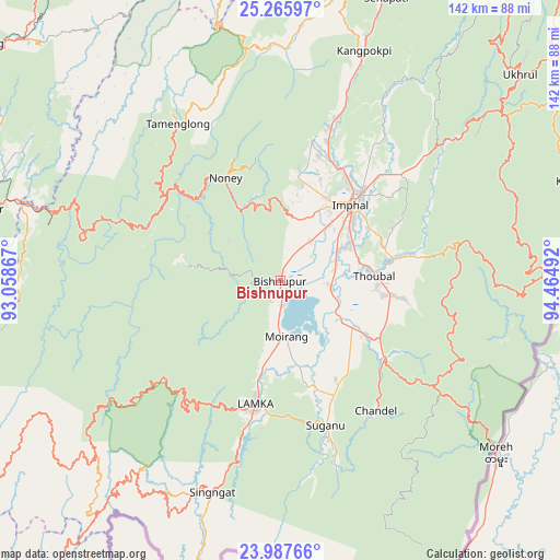
Bishnupur GPS coordinates[2]
24° 37' 42.42" North, 93° 45' 42.444" East
| Map corner | latitude | longitude |
|---|---|---|
| Upper-left | 25.26597°, | 93.05867° |
| Center: | 24.62845°, | 93.76179° |
| Lower-right: | 23.98766°, | 94.46492° |
| Map W x H: | 142.1×142.1 km | = 88.3×88.3mi |
| max Lat: | 34.9274° ⇑38.6% North |
| Bishnupur: | 24.62845° |
| min Lat: | ⇓61.4% South 8.09008° |
| min Long | Bishnupur | max Long |
| 68.82655° | 93.76179° | 96.81° |
| W 98.3%⇐ | ⇒1.7% E |
Elevation
Elevation of Bishnupur is 809 m = 2654 ft, and this is 513.4 m = 1684 ft above average elevation for this country.
| Max E: |
3681 m = 12077 ft | 5.8% |
| Bishnupur | 809 m 2654 ft | |
| Avg. | 295.6 m = 970 ft | |
Min E: |
1 m = 3 ft | 94.2% |
See also: India elevation on elevation.city.
Geographical zone
Bishnupur is located in North temperate zone (between Tropic of Cancer and the Arctic Circle). Distance of this Northern Tropic circle is 132.5 km =82.3 mi to South.| Distance of | km | miles | from Bishnupur |
|---|---|---|---|
| North Pole | 7268.6 | 4516.5 | to North |
| Arctic Circle | 4662.7 | 2897.3 | to North |
| Tropic Cancer | 132.5 | 82.3 | to South |
| Equator | 2738.4 | 1701.6 | to South |


Nearby cities:
15 places around Bishnupur: (largest is in red/bold)
• Chandel
41.3 km =25.7 mi,  143°
143°
• Churāchāndpur
34.1 km =21.2 mi,  195°
195°
• Imphal
27.2 km =16.9 mi,  42°
42°
• Jiribam
67.6 km =42 mi,  286°
286°
• Kakching
26.5 km =16.5 mi,  123°
123°
• Kamjong
80.3 km =49.9 mi,  71°
71°
• Kāngpokpi
62 km =38.5 mi,  19°
19°
• Lakhipur
78.2 km =48.6 mi,  283°
283°
• Mayāng Imphāl
13 km =8.1 mi,  99°
99°
• Moirāng
14.7 km =9.1 mi,  173°
173°
• Pherzawl
70.9 km =44.1 mi,  234°
234°
• Tengnoupal
47.4 km =29.5 mi, 124°
• Thoubāl
23.7 km =14.7 mi,  87°
87°
• Wāngjing
30.8 km =19.1 mi, 98°
• Yairipok
29.4 km =18.3 mi,  79°
79°
Sources, notices
• [Note1] Compared only with cities in India existing in our database
• [Src1] Map data: © OpenStreetMap contributors (CC-BY-SA)
• [Src2] Other city data from geonames.org with taken over terms of usage.
• [Src3] Geographical zone / Annual Mean Temperature by Robert A. Rohde @ Wikipedia
