Biswān geodata
Biswān (Uttar Pradesh) is a populated place; located in India in Asia/Kolkata (GMT+5.5) time zone. With population of 52,516 people, there are 853 cities with bigger population in this country. Compared to other cities in India, 81.8% of cities are located further ↓South; 72.9% of cities are located further ←West and 62.3% of cities have higher elevation than Biswān. Note1


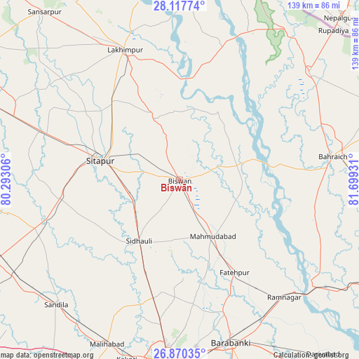
Biswān GPS coordinates[2]
27° 29' 44.916" North, 80° 59' 46.248" East
| Map corner | latitude | longitude |
|---|---|---|
| Upper-left | 28.11774°, | 80.29306° |
| Center: | 27.49581°, | 80.99618° |
| Lower-right: | 26.87035°, | 81.69931° |
| Map W x H: | 138.7×138.7 km | = 86.2×86.2mi |
| max Lat: | 34.9274° ⇑18.2% North |
| Biswān: | 27.49581° |
| min Lat: | ⇓81.8% South 8.09008° |
| min Long | Biswān | max Long |
| 68.82655° | 80.99618° | 96.81° |
| W 72.9%⇐ | ⇒27.1% E |
Elevation
Elevation of Biswān is 136 m = 446 ft, and this is 159.6 m = 524 ft below average elevation for this country.
| Max E: |
3681 m = 12077 ft | 62.3% |
| Avg. | 295.6 m = 970 ft | |
| Biswān | 136 m = 446 ft | |
Min E: |
1 m = 3 ft | 37.7% |
See also: Biswān elevation on elevation.city.
Geographical zone
Biswān is located in North temperate zone (between Tropic of Cancer and the Arctic Circle). Distance of this Northern Tropic circle is 451.3 km =280.4 mi to South.| Distance of | km | miles | from Biswān |
|---|---|---|---|
| North Pole | 6949.8 | 4318.4 | to North |
| Arctic Circle | 4343.9 | 2699.2 | to North |
| Tropic Cancer | 451.3 | 280.4 | to South |
| Equator | 3057.2 | 1899.7 | to South |


Nearby cities:
15 places around Biswān: (largest is in red/bold)
• Amethi
58.2 km =36.2 mi,  5°
5°
• Benīganj
59 km =36.7 mi,  247°
247°
• Dewā
53.8 km =33.4 mi,  161°
161°
• Dhaurahra
56.6 km =35.2 mi, 9°
• Fatehpur
41.7 km =25.9 mi,  149°
149°
• Itaunja
46.9 km =29.1 mi,  192°
192°
• Khairābād
24.1 km =15 mi,  278°
278°
• Kheri
49.4 km =30.7 mi,  336°
336°
• Lakhīmpur
54.6 km =33.9 mi, 337°
• Lāharpur
25.4 km =15.8 mi, 338°
• Mahmudābād
25.7 km =16 mi, 152°
• Maholi
54.8 km =34.1 mi,  289°
289°
• Misrikh
46.4 km =28.8 mi,  261°
261°
• Sidhaulī
28.6 km =17.8 mi,  213°
213°
• Sītāpur
31.8 km =19.8 mi, 283°
Sources, notices
• [Note1] Compared only with cities in India existing in our database
• [Src1] Map data: © OpenStreetMap contributors (CC-BY-SA)
• [Src2] Other city data from geonames.org with taken over terms of usage.
• [Src3] Geographical zone / Annual Mean Temperature by Robert A. Rohde @ Wikipedia
