Lāharpur geodata
Lāharpur (Uttar Pradesh) is a populated place; located in India in Asia/Kolkata (GMT+5.5) time zone. With population of 55,911 people, there are 798 cities with bigger population in this country. Compared to other cities in India, 83.1% of cities are located further ↓South; 72.6% of cities are located further ←West and 61.1% of cities have higher elevation than Lāharpur. Note1


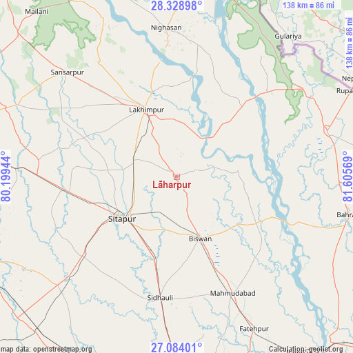
Lāharpur GPS coordinates[2]
27° 42' 29.772" North, 80° 54' 9.216" East
| Map corner | latitude | longitude |
|---|---|---|
| Upper-left | 28.32898°, | 80.19944° |
| Center: | 27.70827°, | 80.90256° |
| Lower-right: | 27.08401°, | 81.60569° |
| Map W x H: | 138.4×138.4 km | = 86×86mi |
| max Lat: | 34.9274° ⇑16.9% North |
| Lāharpur: | 27.70827° |
| min Lat: | ⇓83.1% South 8.09008° |
| min Long | Lāharpur | max Long |
| 68.82655° | 80.90256° | 96.81° |
| W 72.6%⇐ | ⇒27.4% E |
Elevation
Elevation of Lāharpur is 142 m = 466 ft, and this is 153.6 m = 504 ft below average elevation for this country.
| Max E: |
3681 m = 12077 ft | 61.1% |
| Avg. | 295.6 m = 970 ft | |
| Lāharpur | 142 m = 466 ft | |
Min E: |
1 m = 3 ft | 38.9% |
See also: Lāharpur elevation on elevation.city.
Geographical zone
Lāharpur is located in North temperate zone (between Tropic of Cancer and the Arctic Circle). Distance of this Northern Tropic circle is 475 km =295.2 mi to South.| Distance of | km | miles | from Lāharpur |
|---|---|---|---|
| North Pole | 6926.2 | 4303.7 | to North |
| Arctic Circle | 4320.3 | 2684.5 | to North |
| Tropic Cancer | 475 | 295.2 | to South |
| Equator | 3080.9 | 1914.4 | to South |


Nearby cities:
15 places around Lāharpur: (largest is in red/bold)
• Amethi
37.2 km =23.1 mi,  22°
22°
• Benīganj
64.7 km =40.2 mi,  224°
224°
• Biswān
25.4 km =15.8 mi,  158°
158°
• Dhaurahra
37.1 km =23.1 mi,  29°
29°
• Gola Gokarannāth
59.1 km =36.7 mi,  314°
314°
• Gopāmau
63.8 km =39.6 mi,  252°
252°
• Khairābād
24.9 km =15.5 mi, 215°
• Kheri
24 km =14.9 mi,  334°
334°
• Lakhīmpur
29.3 km =18.2 mi,  335°
335°
• Mahmudābād
50.9 km =31.6 mi, 155°
• Maholi
42.5 km =26.4 mi,  263°
263°
• Misrikh
47.8 km =29.7 mi,  229°
229°
• Nānpāra
61.3 km =38.1 mi,  73°
73°
• Sidhaulī
47.9 km =29.8 mi,  188°
188°
• Sītāpur
27.1 km =16.8 mi, 233°
Sources, notices
• [Note1] Compared only with cities in India existing in our database
• [Src1] Map data: © OpenStreetMap contributors (CC-BY-SA)
• [Src2] Other city data from geonames.org with taken over terms of usage.
• [Src3] Geographical zone / Annual Mean Temperature by Robert A. Rohde @ Wikipedia
