Maghar geodata
Maghar (Uttar Pradesh) is a populated place; located in India in Asia/Kolkata (GMT+5.5) time zone. With population of 17,011 people, there are 2285 cities with bigger population in this country. Compared to other cities in India, 76.5% of cities are located further ↓South; 79.7% of cities are located further ←West and 72.1% of cities have higher elevation than Maghar. Note1


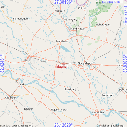
Maghar GPS coordinates[2]
26° 45' 21.096" North, 83° 7' 39.828" East
| Map corner | latitude | longitude |
|---|---|---|
| Upper-left | 27.38196°, | 82.42461° |
| Center: | 26.75586°, | 83.12773° |
| Lower-right: | 26.12629°, | 83.83086° |
| Map W x H: | 139.6×139.6 km | = 86.7×86.7mi |
| max Lat: | 34.9274° ⇑23.5% North |
| Maghar: | 26.75586° |
| min Lat: | ⇓76.5% South 8.09008° |
| min Long | Maghar | max Long |
| 68.82655° | 83.12773° | 96.81° |
| W 79.7%⇐ | ⇒20.3% E |
Elevation
Elevation of Maghar is 84 m = 276 ft, and this is 211.6 m = 694 ft below average elevation for this country.
| Max E: |
3681 m = 12077 ft | 72.1% |
| Avg. | 295.6 m = 970 ft | |
| Maghar | 84 m = 276 ft | |
Min E: |
1 m = 3 ft | 27.9% |
See also: India elevation on elevation.city.
Geographical zone
Maghar is located in North temperate zone (between Tropic of Cancer and the Arctic Circle). Distance of this Northern Tropic circle is 369.1 km =229.3 mi to South.| Distance of | km | miles | from Maghar |
|---|---|---|---|
| North Pole | 7032.1 | 4369.5 | to North |
| Arctic Circle | 4426.2 | 2750.3 | to North |
| Tropic Cancer | 369.1 | 229.3 | to South |
| Equator | 2975 | 1848.6 | to South |


Nearby cities:
15 places around Maghar: (largest is in red/bold)
• Anandnagar
40.9 km =25.4 mi,  20°
20°
• Atraulia
50.3 km =31.3 mi,  200°
200°
• Bastī
41 km =25.5 mi,  275°
275°
• Bishunpur Urf Mahārājganj
55.2 km =34.3 mi,  181°
181°
• Bānsgāon
31.4 km =19.5 mi,  136°
136°
• Bānsi
50.6 km =31.4 mi,  337°
337°
• Captainganj
61.1 km =38 mi,  71°
71°
• Gola Bāzār
50.9 km =31.6 mi,  153°
153°
• Gorakhpur
24 km =14.9 mi,  87°
87°
• Khalīlābād
5.9 km =3.7 mi,  288°
288°
• Mahārāganj
61 km =37.9 mi,  44°
44°
• Mehndāwal
24.5 km =15.2 mi,  355°
355°
• Pipraich
40.4 km =25.1 mi,  78°
78°
• Rūdarpur
59.4 km =36.9 mi,  125°
125°
• Tāndā
52 km =32.3 mi,  243°
243°
Sources, notices
• [Note1] Compared only with cities in India existing in our database
• [Src1] Map data: © OpenStreetMap contributors (CC-BY-SA)
• [Src2] Other city data from geonames.org with taken over terms of usage.
• [Src3] Geographical zone / Annual Mean Temperature by Robert A. Rohde @ Wikipedia
