Bānsi geodata
Bānsi (Uttar Pradesh) is a populated place; located in India in Asia/Kolkata (GMT+5.5) time zone. With population of 39,926 people, there are 1108 cities with bigger population in this country. Compared to other cities in India, 79.9% of cities are located further ↓South; 79.1% of cities are located further ←West and 70.2% of cities have higher elevation than Bānsi. Note1


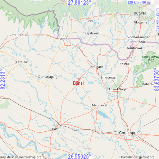
Bānsi GPS coordinates[2]
27° 10' 38.964" North, 82° 56' 3.912" East
| Map corner | latitude | longitude |
|---|---|---|
| Upper-left | 27.80123°, | 82.2313° |
| Center: | 27.17749°, | 82.93442° |
| Lower-right: | 26.55025°, | 83.63755° |
| Map W x H: | 139.1×139.1 km | = 86.4×86.4mi |
| max Lat: | 34.9274° ⇑20.1% North |
| Bānsi: | 27.17749° |
| min Lat: | ⇓79.9% South 8.09008° |
| min Long | Bānsi | max Long |
| 68.82655° | 82.93442° | 96.81° |
| W 79.1%⇐ | ⇒20.9% E |
Elevation
Elevation of Bānsi is 91 m = 299 ft, and this is 204.6 m = 671 ft below average elevation for this country.
| Max E: |
3681 m = 12077 ft | 70.2% |
| Avg. | 295.6 m = 970 ft | |
| Bānsi | 91 m = 299 ft | |
Min E: |
1 m = 3 ft | 29.8% |
See also: India elevation on elevation.city.
Geographical zone
Bānsi is located in North temperate zone (between Tropic of Cancer and the Arctic Circle). Distance of this Northern Tropic circle is 415.9 km =258.4 mi to South.| Distance of | km | miles | from Bānsi |
|---|---|---|---|
| North Pole | 6985.2 | 4340.4 | to North |
| Arctic Circle | 4379.3 | 2721.2 | to North |
| Tropic Cancer | 415.9 | 258.4 | to South |
| Equator | 3021.9 | 1877.7 | to South |


Nearby cities:
15 places around Bānsi: (largest is in red/bold)
• Anandnagar
34.4 km =21.4 mi,  104°
104°
• Bastī
48.4 km =30.1 mi,  206°
206°
• Gorakhpur
62.8 km =39 mi,  136°
136°
• Haraiya
63.1 km =39.2 mi,  227°
227°
• Khalīlābād
47 km =29.2 mi,  163°
163°
• Maghar
50.6 km =31.4 mi, 157°
• Mahārāganj
62.2 km =38.6 mi,  93°
93°
• Mankāpur
71.1 km =44.2 mi,  258°
258°
• Mehndāwal
28.4 km =17.6 mi, 142°
• Nautanwa
55.3 km =34.4 mi,  59°
59°
• Pachperwa
47.1 km =29.3 mi,  322°
322°
• Pipraich
70.4 km =43.7 mi,  123°
123°
• Tulsīpur
64.7 km =40.2 mi,  307°
307°
• Tāndā
75 km =46.6 mi,  201°
201°
• Utraula
53.4 km =33.2 mi,  287°
287°
Sources, notices
• [Note1] Compared only with cities in India existing in our database
• [Src1] Map data: © OpenStreetMap contributors (CC-BY-SA)
• [Src2] Other city data from geonames.org with taken over terms of usage.
• [Src3] Geographical zone / Annual Mean Temperature by Robert A. Rohde @ Wikipedia
