Khalīlābād geodata
Khalīlābād (Uttar Pradesh) is a populated place; located in India in Asia/Kolkata (GMT+5.5) time zone. With population of 45,321 people, there are 979 cities with bigger population in this country. Compared to other cities in India, 76.6% of cities are located further ↓South; 79.5% of cities are located further ←West and 72.1% of cities have higher elevation than Khalīlābād. Note1


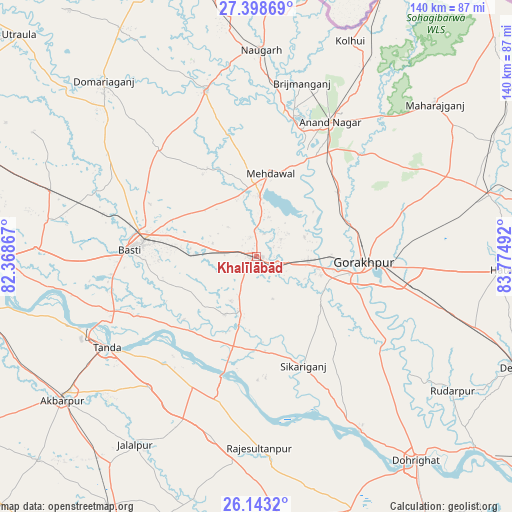
Khalīlābād GPS coordinates[2]
26° 46' 21.648" North, 83° 4' 18.444" East
| Map corner | latitude | longitude |
|---|---|---|
| Upper-left | 27.39869°, | 82.36867° |
| Center: | 26.77268°, | 83.07179° |
| Lower-right: | 26.1432°, | 83.77492° |
| Map W x H: | 139.6×139.6 km | = 86.7×86.7mi |
| max Lat: | 34.9274° ⇑23.4% North |
| Khalīlābād: | 26.77268° |
| min Lat: | ⇓76.6% South 8.09008° |
| min Long | Khalīlābād | max Long |
| 68.82655° | 83.07179° | 96.81° |
| W 79.5%⇐ | ⇒20.5% E |
Elevation
Elevation of Khalīlābād is 84 m = 276 ft, and this is 211.6 m = 694 ft below average elevation for this country.
| Max E: |
3681 m = 12077 ft | 72.1% |
| Avg. | 295.6 m = 970 ft | |
| Khalīlābād | 84 m = 276 ft | |
Min E: |
1 m = 3 ft | 27.9% |
See also: Khalīlābād elevation on elevation.city.
Geographical zone
Khalīlābād is located in North temperate zone (between Tropic of Cancer and the Arctic Circle). Distance of this Northern Tropic circle is 370.9 km =230.5 mi to South.| Distance of | km | miles | from Khalīlābād |
|---|---|---|---|
| North Pole | 7030.2 | 4368.4 | to North |
| Arctic Circle | 4424.3 | 2749.1 | to North |
| Tropic Cancer | 370.9 | 230.5 | to South |
| Equator | 2976.8 | 1849.7 | to South |


Nearby cities:
15 places around Khalīlābād: (largest is in red/bold)
• Anandnagar
41.5 km =25.8 mi,  28°
28°
• Atraulia
50.4 km =31.3 mi,  194°
194°
• Bastī
35.3 km =21.9 mi,  272°
272°
• Bishunpur Urf Mahārājganj
57.3 km =35.6 mi,  175°
175°
• Bānsgāon
36.7 km =22.8 mi,  132°
132°
• Bānsi
47 km =29.2 mi,  343°
343°
• Gola Bāzār
55.2 km =34.3 mi,  149°
149°
• Gorakhpur
29.5 km =18.3 mi,  91°
91°
• Haraiya
60.3 km =37.5 mi, 272°
• Jalālpur
61 km =37.9 mi,  212°
212°
• Maghar
5.9 km =3.7 mi,  108°
108°
• Mahārāganj
63.8 km =39.6 mi,  49°
49°
• Mehndāwal
22.9 km =14.2 mi,  9°
9°
• Pipraich
45.5 km =28.3 mi,  82°
82°
• Tāndā
48 km =29.8 mi,  238°
238°
Sources, notices
• [Note1] Compared only with cities in India existing in our database
• [Src1] Map data: © OpenStreetMap contributors (CC-BY-SA)
• [Src2] Other city data from geonames.org with taken over terms of usage.
• [Src3] Geographical zone / Annual Mean Temperature by Robert A. Rohde @ Wikipedia
