Lakhīmpur geodata
Lakhīmpur (Uttar Pradesh) is a populated place; located in India in Asia/Kolkata (GMT+5.5) time zone. With population of 140,223 people, there are 306 cities with bigger population in this country. Compared to other cities in India, 84.2% of cities are located further ↓South; 72.1% of cities are located further ←West and 59.3% of cities have higher elevation than Lakhīmpur. Note1


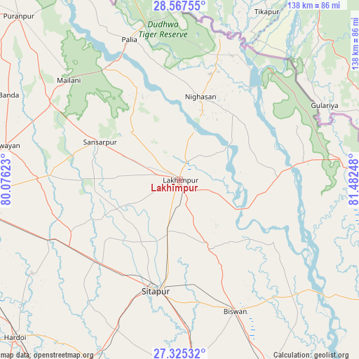
Lakhīmpur GPS coordinates[2]
27° 56' 53.592" North, 80° 46' 45.66" East
| Map corner | latitude | longitude |
|---|---|---|
| Upper-left | 28.56755°, | 80.07623° |
| Center: | 27.94822°, | 80.77935° |
| Lower-right: | 27.32532°, | 81.48248° |
| Map W x H: | 138.1×138.1 km | = 85.8×85.8mi |
| max Lat: | 34.9274° ⇑15.8% North |
| Lakhīmpur: | 27.94822° |
| min Lat: | ⇓84.2% South 8.09008° |
| min Long | Lakhīmpur | max Long |
| 68.82655° | 80.77935° | 96.81° |
| W 72.1%⇐ | ⇒27.9% E |
Elevation
Elevation of Lakhīmpur is 152 m = 499 ft, and this is 143.6 m = 471 ft below average elevation for this country.
| Max E: |
3681 m = 12077 ft | 59.3% |
| Avg. | 295.6 m = 970 ft | |
| Lakhīmpur | 152 m = 499 ft | |
Min E: |
1 m = 3 ft | 40.7% |
See also: Lakhīmpur elevation on elevation.city.
Geographical zone
Lakhīmpur is located in North temperate zone (between Tropic of Cancer and the Arctic Circle). Distance of this Northern Tropic circle is 501.6 km =311.7 mi to South.| Distance of | km | miles | from Lakhīmpur |
|---|---|---|---|
| North Pole | 6899.5 | 4287.1 | to North |
| Arctic Circle | 4293.6 | 2667.9 | to North |
| Tropic Cancer | 501.6 | 311.7 | to South |
| Equator | 3107.6 | 1931 | to South |


Nearby cities:
15 places around Lakhīmpur: (largest is in red/bold)
• Amethi
27.6 km =17.1 mi,  74°
74°
• Biswān
54.6 km =33.9 mi,  157°
157°
• Dhaurahra
31 km =19.3 mi,  79°
79°
• Gola Gokarannāth
33.6 km =20.9 mi,  295°
295°
• Gopāmau
66.9 km =41.6 mi,  226°
226°
• Khairābād
46.9 km =29.1 mi,  182°
182°
• Kheri
5.3 km =3.3 mi, 160°
• Khūtār
57.4 km =35.7 mi, 299°
• Lāharpur
29.3 km =18.2 mi, 155°
• Maholi
43.6 km =27.1 mi,  223°
223°
• Mailāni
57.2 km =35.5 mi,  311°
311°
• Misrikh
62.4 km =38.8 mi,  203°
203°
• Mohanpur
62.4 km =38.8 mi, 302°
• Paliā Kalān
57.2 km =35.5 mi,  340°
340°
• Sītāpur
44 km =27.3 mi,  192°
192°
Sources, notices
• [Note1] Compared only with cities in India existing in our database
• [Src1] Map data: © OpenStreetMap contributors (CC-BY-SA)
• [Src2] Other city data from geonames.org with taken over terms of usage.
• [Src3] Geographical zone / Annual Mean Temperature by Robert A. Rohde @ Wikipedia
