Khūtār geodata
Khūtār (Uttar Pradesh) is a populated place; located in India in Asia/Kolkata (GMT+5.5) time zone. With population of 15,618 people, there are 2405 cities with bigger population in this country. Compared to other cities in India, 85.3% of cities are located further ↓South; 70.1% of cities are located further ←West and 56.6% of cities have higher elevation than Khūtār. Note1


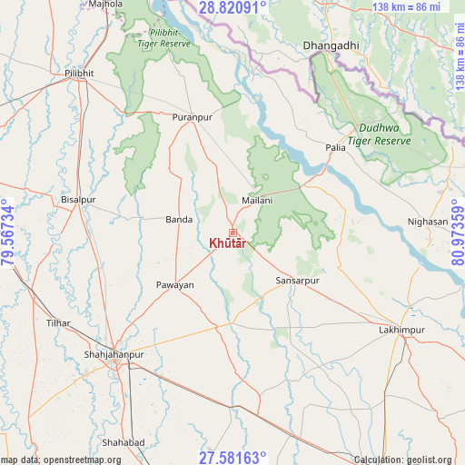
Khūtār GPS coordinates[2]
28° 12' 11.052" North, 80° 16' 13.656" East
| Map corner | latitude | longitude |
|---|---|---|
| Upper-left | 28.82091°, | 79.56734° |
| Center: | 28.20307°, | 80.27046° |
| Lower-right: | 27.58163°, | 80.97359° |
| Map W x H: | 137.8×137.8 km | = 85.6×85.6mi |
| max Lat: | 34.9274° ⇑14.7% North |
| Khūtār: | 28.20307° |
| min Lat: | ⇓85.3% South 8.09008° |
| min Long | Khūtār | max Long |
| 68.82655° | 80.27046° | 96.81° |
| W 70.1%⇐ | ⇒29.9% E |
Elevation
Elevation of Khūtār is 167 m = 548 ft, and this is 128.6 m = 422 ft below average elevation for this country.
| Max E: |
3681 m = 12077 ft | 56.6% |
| Avg. | 295.6 m = 970 ft | |
| Khūtār | 167 m = 548 ft | |
Min E: |
1 m = 3 ft | 43.4% |
See also: India elevation on elevation.city.
Geographical zone
Khūtār is located in North temperate zone (between Tropic of Cancer and the Arctic Circle). Distance of this Northern Tropic circle is 530 km =329.3 mi to South.| Distance of | km | miles | from Khūtār |
|---|---|---|---|
| North Pole | 6871.2 | 4269.6 | to North |
| Arctic Circle | 4265.3 | 2650.3 | to North |
| Tropic Cancer | 530 | 329.3 | to South |
| Equator | 3135.9 | 1948.6 | to South |


Nearby cities:
15 places around Khūtār: (largest is in red/bold)
• Barkhera Kalān
53.2 km =33.1 mi,  301°
301°
• Bilsanda
31.6 km =19.6 mi,  278°
278°
• Bīsalpur
46.7 km =29 mi, 282°
• Gola Gokarannāth
24 km =14.9 mi,  125°
125°
• Kheri
61.5 km =38.2 mi,  122°
122°
• Khudāganj
54.8 km =34.1 mi,  263°
263°
• Kālīnagar
49.9 km =31 mi,  338°
338°
• Lakhīmpur
57.4 km =35.7 mi, 119°
• Mailāni
12.1 km =7.5 mi,  36°
36°
• Mohanpur
6 km =3.7 mi, 335°
• Paliā Kalān
39.7 km =24.7 mi,  50°
50°
• Pawāyan
22.4 km =13.9 mi,  227°
227°
• Pūranpur
36.5 km =22.7 mi, 340°
• Shāhjānpur
50.3 km =31.3 mi,  224°
224°
• Tilhar
58.6 km =36.4 mi,  242°
242°
Sources, notices
• [Note1] Compared only with cities in India existing in our database
• [Src1] Map data: © OpenStreetMap contributors (CC-BY-SA)
• [Src2] Other city data from geonames.org with taken over terms of usage.
• [Src3] Geographical zone / Annual Mean Temperature by Robert A. Rohde @ Wikipedia
