Amethi geodata
Amethi (Uttar Pradesh) is a populated place; located in India in Asia/Kolkata (GMT+5.5) time zone. With population of 12,206 people, there are 2725 cities with bigger population in this country. Compared to other cities in India, 84.5% of cities are located further ↓South; 73.1% of cities are located further ←West and 62.8% of cities have higher elevation than Amethi. Note1


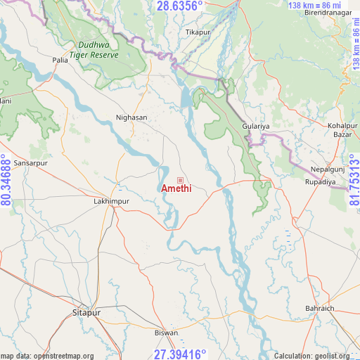
Amethi GPS coordinates[2]
28° 1' 0.012" North, 81° 3' 0" East
| Map corner | latitude | longitude |
|---|---|---|
| Upper-left | 28.6356°, | 80.34688° |
| Center: | 28.01667°, | 81.05° |
| Lower-right: | 27.39416°, | 81.75313° |
| Map W x H: | 138×138 km | = 85.7×85.7mi |
| max Lat: | 34.9274° ⇑15.5% North |
| Amethi: | 28.01667° |
| min Lat: | ⇓84.5% South 8.09008° |
| min Long | Amethi | max Long |
| 68.82655° | 81.05° | 96.81° |
| W 73.1%⇐ | ⇒26.9% E |
Elevation
Elevation of Amethi is 133 m = 436 ft, and this is 162.6 m = 533 ft below average elevation for this country.
| Max E: |
3681 m = 12077 ft | 62.8% |
| Avg. | 295.6 m = 970 ft | |
| Amethi | 133 m = 436 ft | |
Min E: |
1 m = 3 ft | 37.2% |
See also: India elevation on elevation.city.
Geographical zone
Amethi is located in North temperate zone (between Tropic of Cancer and the Arctic Circle). Distance of this Northern Tropic circle is 509.2 km =316.4 mi to South.| Distance of | km | miles | from Amethi |
|---|---|---|---|
| North Pole | 6891.9 | 4282.4 | to North |
| Arctic Circle | 4286 | 2663.2 | to North |
| Tropic Cancer | 509.2 | 316.4 | to South |
| Equator | 3115.2 | 1935.7 | to South |


Nearby cities:
15 places around Amethi: (largest is in red/bold)
• Bahraigh
72.7 km =45.2 mi,  132°
132°
• Biswān
58.2 km =36.2 mi,  185°
185°
• Dhaurahra
4.4 km =2.7 mi,  117°
117°
• Gola Gokarannāth
57.3 km =35.6 mi,  276°
276°
• Khairābād
61.7 km =38.3 mi,  208°
208°
• Kheri
27.8 km =17.3 mi,  243°
243°
• Khūtār
79.2 km =49.2 mi,  285°
285°
• Lakhīmpur
27.6 km =17.1 mi,  254°
254°
• Lāharpur
37.2 km =23.1 mi,  202°
202°
• Mahmudābād
80.9 km =50.3 mi,  175°
175°
• Maholi
68.9 km =42.8 mi, 235°
• Mailāni
75.6 km =47 mi, 293°
• Nānpāra
47.4 km =29.5 mi,  110°
110°
• Paliā Kalān
65.1 km =40.5 mi,  315°
315°
• Sītāpur
62.1 km =38.6 mi,  215°
215°
Sources, notices
• [Note1] Compared only with cities in India existing in our database
• [Src1] Map data: © OpenStreetMap contributors (CC-BY-SA)
• [Src2] Other city data from geonames.org with taken over terms of usage.
• [Src3] Geographical zone / Annual Mean Temperature by Robert A. Rohde @ Wikipedia
