Kheri geodata
Kheri (Uttar Pradesh) is a populated place; located in India in Asia/Kolkata (GMT+5.5) time zone. With population of 26,327 people, there are 1619 cities with bigger population in this country. Compared to other cities in India, 84.1% of cities are located further ↓South; 72.2% of cities are located further ←West and 59.9% of cities have higher elevation than Kheri. Note1


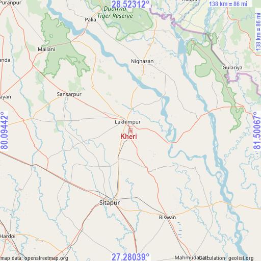
Kheri GPS coordinates[2]
27° 54' 12.744" North, 80° 47' 51.144" East
| Map corner | latitude | longitude |
|---|---|---|
| Upper-left | 28.52312°, | 80.09442° |
| Center: | 27.90354°, | 80.79754° |
| Lower-right: | 27.28039°, | 81.50067° |
| Map W x H: | 138.2×138.2 km | = 85.9×85.9mi |
| max Lat: | 34.9274° ⇑15.9% North |
| Kheri: | 27.90354° |
| min Lat: | ⇓84.1% South 8.09008° |
| min Long | Kheri | max Long |
| 68.82655° | 80.79754° | 96.81° |
| W 72.2%⇐ | ⇒27.8% E |
Elevation
Elevation of Kheri is 149 m = 489 ft, and this is 146.6 m = 481 ft below average elevation for this country.
| Max E: |
3681 m = 12077 ft | 59.9% |
| Avg. | 295.6 m = 970 ft | |
| Kheri | 149 m = 489 ft | |
Min E: |
1 m = 3 ft | 40.1% |
See also: India elevation on elevation.city.
Geographical zone
Kheri is located in North temperate zone (between Tropic of Cancer and the Arctic Circle). Distance of this Northern Tropic circle is 496.7 km =308.6 mi to South.| Distance of | km | miles | from Kheri |
|---|---|---|---|
| North Pole | 6904.5 | 4290.3 | to North |
| Arctic Circle | 4298.6 | 2671 | to North |
| Tropic Cancer | 496.7 | 308.6 | to South |
| Equator | 3102.6 | 1927.9 | to South |


Nearby cities:
15 places around Kheri: (largest is in red/bold)
• Amethi
27.8 km =17.3 mi,  63°
63°
• Biswān
49.4 km =30.7 mi,  156°
156°
• Dhaurahra
30.6 km =19 mi,  69°
69°
• Gola Gokarannāth
37.5 km =23.3 mi,  301°
301°
• Gopāmau
65 km =40.4 mi,  230°
230°
• Khairābād
42.1 km =26.2 mi,  185°
185°
• Khūtār
61.5 km =38.2 mi, 302°
• Lakhīmpur
5.3 km =3.3 mi,  340°
340°
• Lāharpur
24 km =14.9 mi,  154°
154°
• Maholi
41.5 km =25.8 mi, 230°
• Mailāni
61.9 km =38.5 mi,  314°
314°
• Misrikh
58.7 km =36.5 mi,  206°
206°
• Paliā Kalān
62.5 km =38.8 mi, 340°
• Pihānī
66.4 km =41.3 mi,  241°
241°
• Sītāpur
39.6 km =24.6 mi,  196°
196°
Sources, notices
• [Note1] Compared only with cities in India existing in our database
• [Src1] Map data: © OpenStreetMap contributors (CC-BY-SA)
• [Src2] Other city data from geonames.org with taken over terms of usage.
• [Src3] Geographical zone / Annual Mean Temperature by Robert A. Rohde @ Wikipedia
