Purnia geodata
Purnia (Bihar) is a populated place; located in India in Asia/Kolkata (GMT+5.5) time zone. With population of 198,453 people, there are 214 cities with bigger population in this country. Compared to other cities in India, 69% of cities are located further ↓South; 90.1% of cities are located further ←West and 81.1% of cities have higher elevation than Purnia. Note1


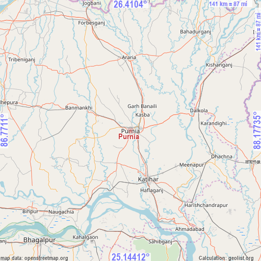
Purnia GPS coordinates[2]
25° 46' 44.22" North, 87° 28' 27.192" East
| Map corner | latitude | longitude |
|---|---|---|
| Upper-left | 26.4104°, | 86.7711° |
| Center: | 25.77895°, | 87.47422° |
| Lower-right: | 25.14412°, | 88.17735° |
| Map W x H: | 140.8×140.8 km | = 87.5×87.5mi |
| max Lat: | 34.9274° ⇑31% North |
| Purnia: | 25.77895° |
| min Lat: | ⇓69% South 8.09008° |
| min Long | Purnia | max Long |
| 68.82655° | 87.47422° | 96.81° |
| W 90.1%⇐ | ⇒9.9% E |
Elevation
Elevation of Purnia is 44 m = 144 ft, and this is 251.6 m = 825 ft below average elevation for this country.
| Max E: |
3681 m = 12077 ft | 81.1% |
| Avg. | 295.6 m = 970 ft | |
| Purnia | 44 m = 144 ft | |
Min E: |
1 m = 3 ft | 18.9% |
See also: Purnia elevation on elevation.city.
Geographical zone
Purnia is located in North temperate zone (between Tropic of Cancer and the Arctic Circle). Distance of this Northern Tropic circle is 260.4 km =161.8 mi to South.| Distance of | km | miles | from Purnia |
|---|---|---|---|
| North Pole | 7140.7 | 4437 | to North |
| Arctic Circle | 4534.8 | 2817.8 | to North |
| Tropic Cancer | 260.4 | 161.8 | to South |
| Equator | 2866.4 | 1781.1 | to South |


Nearby cities:
15 places around Purnia: (largest is in red/bold)
• Arāria
41.4 km =25.7 mi,  5°
5°
• Baisi
28.7 km =17.8 mi,  70°
70°
• Banmankhi
30.6 km =19 mi,  293°
293°
• Bihārīganj
48.9 km =30.4 mi,  264°
264°
• Dalkola
38.2 km =23.7 mi, 73°
• Forbesganj
61.8 km =38.4 mi,  340°
340°
• Kasba
10.7 km =6.6 mi,  36°
36°
• Katihar
28.4 km =17.6 mi,  160°
160°
• Kishanganj
60.1 km =37.3 mi,  53°
53°
• Manihāri
51.1 km =31.8 mi, 163°
• Murlīganj
49.6 km =30.8 mi, 285°
• Naugachhia
57.5 km =35.7 mi,  220°
220°
• Raghunāthpur
46.9 km =29.1 mi,  108°
108°
• Shahbazpur
61.4 km =38.2 mi, 342°
• Sāhibganj
61.6 km =38.3 mi, 164°
Sources, notices
• [Note1] Compared only with cities in India existing in our database
• [Src1] Map data: © OpenStreetMap contributors (CC-BY-SA)
• [Src2] Other city data from geonames.org with taken over terms of usage.
• [Src3] Geographical zone / Annual Mean Temperature by Robert A. Rohde @ Wikipedia
