Kasba geodata
Kasba (Bihar) is a populated place; located in India in Asia/Kolkata (GMT+5.5) time zone. With population of 26,937 people, there are 1587 cities with bigger population in this country. Compared to other cities in India, 69.3% of cities are located further ↓South; 90.3% of cities are located further ←West and 80.2% of cities have higher elevation than Kasba. Note1


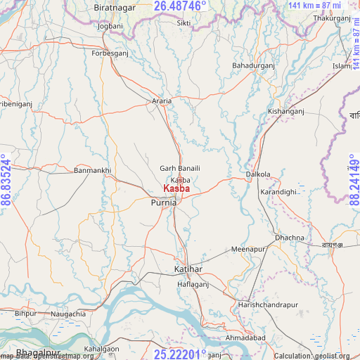
Kasba GPS coordinates[2]
25° 51' 23.148" North, 87° 32' 18.096" East
| Map corner | latitude | longitude |
|---|---|---|
| Upper-left | 26.48746°, | 86.83524° |
| Center: | 25.85643°, | 87.53836° |
| Lower-right: | 25.22201°, | 88.24149° |
| Map W x H: | 140.7×140.7 km | = 87.4×87.4mi |
| max Lat: | 34.9274° ⇑30.7% North |
| Kasba: | 25.85643° |
| min Lat: | ⇓69.3% South 8.09008° |
| min Long | Kasba | max Long |
| 68.82655° | 87.53836° | 96.81° |
| W 90.3%⇐ | ⇒9.7% E |
Elevation
Elevation of Kasba is 47 m = 154 ft, and this is 248.6 m = 816 ft below average elevation for this country.
| Max E: |
3681 m = 12077 ft | 80.2% |
| Avg. | 295.6 m = 970 ft | |
| Kasba | 47 m = 154 ft | |
Min E: |
1 m = 3 ft | 19.8% |
See also: India elevation on elevation.city.
Geographical zone
Kasba is located in North temperate zone (between Tropic of Cancer and the Arctic Circle). Distance of this Northern Tropic circle is 269 km =167.1 mi to South.| Distance of | km | miles | from Kasba |
|---|---|---|---|
| North Pole | 7132.1 | 4431.7 | to North |
| Arctic Circle | 4526.2 | 2812.4 | to North |
| Tropic Cancer | 269 | 167.1 | to South |
| Equator | 2875 | 1786.4 | to South |


Nearby cities:
15 places around Kasba: (largest is in red/bold)
• Arāria
32.7 km =20.3 mi,  355°
355°
• Bahādurganj
53.4 km =33.2 mi,  32°
32°
• Baisi
20.7 km =12.9 mi,  87°
87°
• Banmankhi
34.6 km =21.5 mi,  275°
275°
• Bihārīganj
56.7 km =35.2 mi,  256°
256°
• Dalkola
30.3 km =18.8 mi, 85°
• Forbesganj
56.6 km =35.2 mi,  331°
331°
• Katihar
35.5 km =22.1 mi,  174°
174°
• Kishanganj
49.8 km =30.9 mi,  56°
56°
• Manihāri
58.1 km =36.1 mi, 171°
• Murlīganj
54.5 km =33.9 mi,  274°
274°
• Purnia
10.7 km =6.6 mi,  216°
216°
• Raghunāthpur
44.7 km =27.8 mi,  121°
121°
• Rāiganj
64.7 km =40.2 mi,  114°
114°
• Shahbazpur
55.8 km =34.7 mi, 333°
Sources, notices
• [Note1] Compared only with cities in India existing in our database
• [Src1] Map data: © OpenStreetMap contributors (CC-BY-SA)
• [Src2] Other city data from geonames.org with taken over terms of usage.
• [Src3] Geographical zone / Annual Mean Temperature by Robert A. Rohde @ Wikipedia
