Shahbazpur geodata
Shahbazpur (Bihar) is a populated place; located in India in Asia/Kolkata (GMT+5.5) time zone. With population of 38,000 people, there are 1158 cities with bigger population in this country. Compared to other cities in India, 73% of cities are located further ↓South; 89.8% of cities are located further ←West and 75.7% of cities have higher elevation than Shahbazpur. Note1


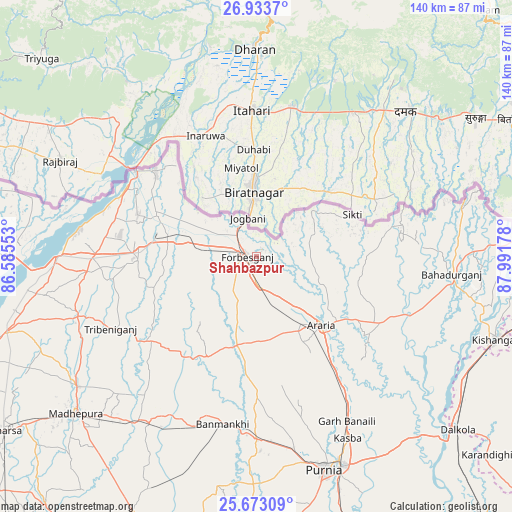
Shahbazpur GPS coordinates[2]
26° 18' 18.396" North, 87° 17' 19.14" East
| Map corner | latitude | longitude |
|---|---|---|
| Upper-left | 26.9337°, | 86.58553° |
| Center: | 26.30511°, | 87.28865° |
| Lower-right: | 25.67309°, | 87.99178° |
| Map W x H: | 140.2×140.2 km | = 87.1×87.1mi |
| max Lat: | 34.9274° ⇑27% North |
| Shahbazpur: | 26.30511° |
| min Lat: | ⇓73% South 8.09008° |
| min Long | Shahbazpur | max Long |
| 68.82655° | 87.28865° | 96.81° |
| W 89.8%⇐ | ⇒10.2% E |
Elevation
Elevation of Shahbazpur is 65 m = 213 ft, and this is 230.6 m = 757 ft below average elevation for this country.
| Max E: |
3681 m = 12077 ft | 75.7% |
| Avg. | 295.6 m = 970 ft | |
| Shahbazpur | 65 m = 213 ft | |
Min E: |
1 m = 3 ft | 24.3% |
See also: India elevation on elevation.city.
Geographical zone
Shahbazpur is located in North temperate zone (between Tropic of Cancer and the Arctic Circle). Distance of this Northern Tropic circle is 318.9 km =198.2 mi to South.| Distance of | km | miles | from Shahbazpur |
|---|---|---|---|
| North Pole | 7082.2 | 4400.7 | to North |
| Arctic Circle | 4476.3 | 2781.4 | to North |
| Tropic Cancer | 318.9 | 198.2 | to South |
| Equator | 2924.9 | 1817.4 | to South |


Nearby cities:
15 places around Shahbazpur: (largest is in red/bold)
• Arāria
28.3 km =17.6 mi,  127°
127°
• Bahādurganj
53.6 km =33.3 mi,  95°
95°
• Baisi
67 km =41.6 mi,  137°
137°
• Banmankhi
47.3 km =29.4 mi,  191°
191°
• Bhawanipur
30.8 km =19.1 mi,  302°
302°
• Bīrpur
35.6 km =22.1 mi,  309°
309°
• Chhātāpur
29.9 km =18.6 mi,  251°
251°
• Forbesganj
2.3 km =1.4 mi,  262°
262°
• Jogbani
10.7 km =6.6 mi,  347°
347°
• Kasba
55.8 km =34.7 mi,  153°
153°
• Kishanganj
70.2 km =43.6 mi,  108°
108°
• Madhipura
65.4 km =40.6 mi,  229°
229°
• Murlīganj
54 km =33.6 mi,  212°
212°
• Nirmāli
70.1 km =43.6 mi,  270°
270°
• Purnia
61.4 km =38.2 mi,  162°
162°
Sources, notices
• [Note1] Compared only with cities in India existing in our database
• [Src1] Map data: © OpenStreetMap contributors (CC-BY-SA)
• [Src2] Other city data from geonames.org with taken over terms of usage.
• [Src3] Geographical zone / Annual Mean Temperature by Robert A. Rohde @ Wikipedia
