Katihar geodata
Katihar (Bihar) is a populated place; located in India in Asia/Kolkata (GMT+5.5) time zone. With population of 192,555 people, there are 222 cities with bigger population in this country. Compared to other cities in India, 67.2% of cities are located further ↓South; 90.4% of cities are located further ←West and 83.9% of cities have higher elevation than Katihar. Note1


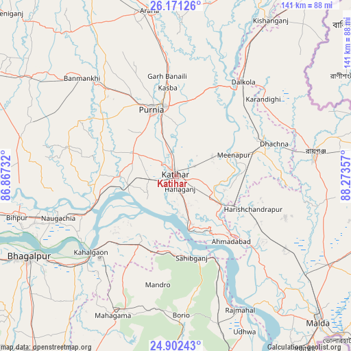
Katihar GPS coordinates[2]
25° 32' 18.672" North, 87° 34' 13.584" East
| Map corner | latitude | longitude |
|---|---|---|
| Upper-left | 26.17126°, | 86.86732° |
| Center: | 25.53852°, | 87.57044° |
| Lower-right: | 24.90243°, | 88.27357° |
| Map W x H: | 141.1×141.1 km | = 87.7×87.7mi |
| max Lat: | 34.9274° ⇑32.8% North |
| Katihar: | 25.53852° |
| min Lat: | ⇓67.2% South 8.09008° |
| min Long | Katihar | max Long |
| 68.82655° | 87.57044° | 96.81° |
| W 90.4%⇐ | ⇒9.6% E |
Elevation
Elevation of Katihar is 34 m = 112 ft, and this is 261.6 m = 858 ft below average elevation for this country.
| Max E: |
3681 m = 12077 ft | 83.9% |
| Avg. | 295.6 m = 970 ft | |
| Katihar | 34 m = 112 ft | |
Min E: |
1 m = 3 ft | 16.1% |
See also: Katihar elevation on elevation.city.
Geographical zone
Katihar is located in North temperate zone (between Tropic of Cancer and the Arctic Circle). Distance of this Northern Tropic circle is 233.7 km =145.2 mi to South.| Distance of | km | miles | from Katihar |
|---|---|---|---|
| North Pole | 7167.4 | 4453.6 | to North |
| Arctic Circle | 4561.6 | 2834.4 | to North |
| Tropic Cancer | 233.7 | 145.2 | to South |
| Equator | 2839.6 | 1764.4 | to South |


Nearby cities:
15 places around Katihar: (largest is in red/bold)
• Arāria
68.2 km =42.4 mi,  355°
355°
• Baisi
40.1 km =24.9 mi,  25°
25°
• Banmankhi
54.2 km =33.7 mi,  315°
315°
• Bihārīganj
62.3 km =38.7 mi,  290°
290°
• Colgong
45.7 km =28.4 mi,  227°
227°
• Dalkola
46.2 km =28.7 mi,  35°
35°
• Ghoga
54.8 km =34.1 mi, 229°
• Kasba
35.5 km =22.1 mi,  354°
354°
• Manihāri
22.7 km =14.1 mi,  167°
167°
• Naugachhia
50.2 km =31.2 mi,  250°
250°
• Purnia
28.4 km =17.6 mi,  340°
340°
• Raghunāthpur
36.8 km =22.9 mi,  71°
71°
• Rāiganj
56.2 km =34.9 mi,  81°
81°
• Rājmahal
60 km =37.3 mi,  154°
154°
• Sāhibganj
33.4 km =20.8 mi, 168°
Sources, notices
• [Note1] Compared only with cities in India existing in our database
• [Src1] Map data: © OpenStreetMap contributors (CC-BY-SA)
• [Src2] Other city data from geonames.org with taken over terms of usage.
• [Src3] Geographical zone / Annual Mean Temperature by Robert A. Rohde @ Wikipedia
