Forbesganj geodata
Forbesganj (Bihar) is a populated place; located in India in Asia/Kolkata (GMT+5.5) time zone. With population of 45,098 people, there are 984 cities with bigger population in this country. Compared to other cities in India, 73% of cities are located further ↓South; 89.8% of cities are located further ←West and 75.7% of cities have higher elevation than Forbesganj. Note1


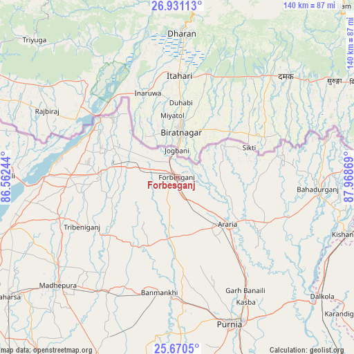
Forbesganj GPS coordinates[2]
26° 18' 9.108" North, 87° 15' 56.016" East
| Map corner | latitude | longitude |
|---|---|---|
| Upper-left | 26.93113°, | 86.56244° |
| Center: | 26.30253°, | 87.26556° |
| Lower-right: | 25.6705°, | 87.96869° |
| Map W x H: | 140.2×140.2 km | = 87.1×87.1mi |
| max Lat: | 34.9274° ⇑27% North |
| Forbesganj: | 26.30253° |
| min Lat: | ⇓73% South 8.09008° |
| min Long | Forbesganj | max Long |
| 68.82655° | 87.26556° | 96.81° |
| W 89.8%⇐ | ⇒10.2% E |
Elevation
Elevation of Forbesganj is 65 m = 213 ft, and this is 230.6 m = 757 ft below average elevation for this country.
| Max E: |
3681 m = 12077 ft | 75.7% |
| Avg. | 295.6 m = 970 ft | |
| Forbesganj | 65 m = 213 ft | |
Min E: |
1 m = 3 ft | 24.3% |
See also: Forbesganj elevation on elevation.city.
Geographical zone
Forbesganj is located in North temperate zone (between Tropic of Cancer and the Arctic Circle). Distance of this Northern Tropic circle is 318.6 km =198 mi to South.| Distance of | km | miles | from Forbesganj |
|---|---|---|---|
| North Pole | 7082.5 | 4400.9 | to North |
| Arctic Circle | 4476.6 | 2781.6 | to North |
| Tropic Cancer | 318.6 | 198 | to South |
| Equator | 2924.6 | 1817.3 | to South |


Nearby cities:
15 places around Forbesganj: (largest is in red/bold)
• Arāria
30 km =18.6 mi,  124°
124°
• Bahādurganj
55.9 km =34.7 mi,  94°
94°
• Baisi
68.4 km =42.5 mi,  135°
135°
• Banmankhi
46.6 km =29 mi,  188°
188°
• Bhawanipur
29.1 km =18.1 mi,  305°
305°
• Bihārīganj
69 km =42.9 mi,  203°
203°
• Bīrpur
34.1 km =21.2 mi, 312°
• Chhātāpur
27.6 km =17.1 mi,  250°
250°
• Jogbani
10.7 km =6.6 mi,  359°
359°
• Kasba
56.6 km =35.2 mi,  151°
151°
• Madhipura
63.4 km =39.4 mi,  228°
228°
• Murlīganj
52.5 km =32.6 mi,  210°
210°
• Nirmāli
67.8 km =42.1 mi,  271°
271°
• Purnia
61.8 km =38.4 mi,  160°
160°
• Shahbazpur
2.3 km =1.4 mi,  82°
82°
Sources, notices
• [Note1] Compared only with cities in India existing in our database
• [Src1] Map data: © OpenStreetMap contributors (CC-BY-SA)
• [Src2] Other city data from geonames.org with taken over terms of usage.
• [Src3] Geographical zone / Annual Mean Temperature by Robert A. Rohde @ Wikipedia
