Rāy geodata
Rāy (Jharkhand) is a populated place; located in India in Asia/Kolkata (GMT+5.5) time zone. With population of 5,949 people, there are 3294 cities with bigger population in this country. Compared to other cities in India, 56% of cities are located further ↓South; 84.4% of cities are located further ←West and 78% of cities have lower elevation than Rāy. Note1


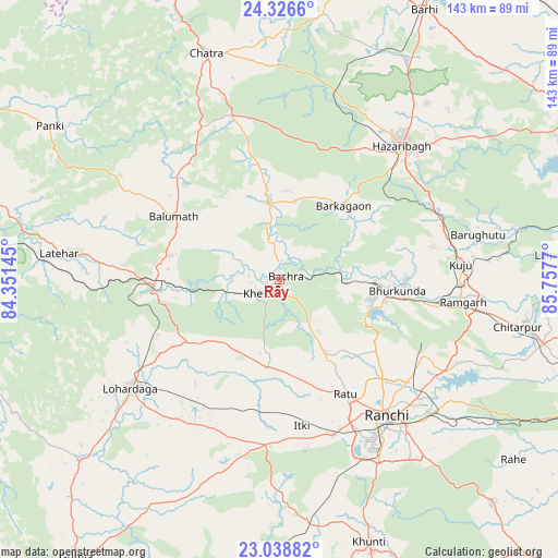
Rāy GPS coordinates[2]
23° 41' 3.48" North, 85° 3' 16.452" East
| Map corner | latitude | longitude |
|---|---|---|
| Upper-left | 24.3266°, | 84.35145° |
| Center: | 23.6843°, | 85.05457° |
| Lower-right: | 23.03882°, | 85.7577° |
| Map W x H: | 143.2×143.2 km | = 89×89mi |
| max Lat: | 34.9274° ⇑44% North |
| Rāy: | 23.6843° |
| min Lat: | ⇓56% South 8.09008° |
| min Long | Rāy | max Long |
| 68.82655° | 85.05457° | 96.81° |
| W 84.4%⇐ | ⇒15.6% E |
Elevation
Elevation of Rāy is 431 m = 1414 ft, and this is 135.4 m = 444 ft above average elevation for this country.
| Max E: |
3681 m = 12077 ft | 22% |
| Rāy | 431 m 1414 ft | |
| Avg. | 295.6 m = 970 ft | |
Min E: |
1 m = 3 ft | 78% |
See also: India elevation on elevation.city.
Geographical zone
Rāy is located in North temperate zone (between Tropic of Cancer and the Arctic Circle). Distance of this Northern Tropic circle is 27.5 km =17.1 mi to South.| Distance of | km | miles | from Rāy |
|---|---|---|---|
| North Pole | 7373.6 | 4581.7 | to North |
| Arctic Circle | 4767.7 | 2962.5 | to North |
| Tropic Cancer | 27.5 | 17.1 | to South |
| Equator | 2633.4 | 1636.3 | to South |


Nearby cities:
15 places around Rāy: (largest is in red/bold)
• Barkā Kānā
42.6 km =26.5 mi,  99°
99°
• Būndu
79.8 km =49.6 mi,  136°
136°
• Chatrā
61 km =37.9 mi,  342°
342°
• Gumia
79.4 km =49.3 mi,  80°
80°
• Gumlā
88.3 km =54.9 mi,  216°
216°
• Hazāribāgh
46.4 km =28.8 mi,  42°
42°
• Khunti
71.4 km =44.4 mi,  161°
161°
• Kuju
46.6 km =29 mi, 84°
• Kānke
38.8 km =24.1 mi, 135°
• Lohārdagā
47.3 km =29.4 mi,  233°
233°
• Lātehār
56.9 km =35.4 mi,  276°
276°
• Neturhāt
83.5 km =51.9 mi,  253°
253°
• Ranchi
46 km =28.6 mi,  145°
145°
• Rāmgarh
47.9 km =29.8 mi, 97°
• patamda
77.7 km =48.3 mi,  28°
28°
Sources, notices
• [Note1] Compared only with cities in India existing in our database
• [Src1] Map data: © OpenStreetMap contributors (CC-BY-SA)
• [Src2] Other city data from geonames.org with taken over terms of usage.
• [Src3] Geographical zone / Annual Mean Temperature by Robert A. Rohde @ Wikipedia
