Kesinga geodata
Kesinga (Odisha) is a populated place; located in India in Asia/Kolkata (GMT+5.5) time zone. With population of 17,994 people, there are 2199 cities with bigger population in this country. Compared to other cities in India, 64.6% of cities are located further ↑North; 80% of cities are located further ←West and 51.3% of cities have higher elevation than Kesinga. Note1


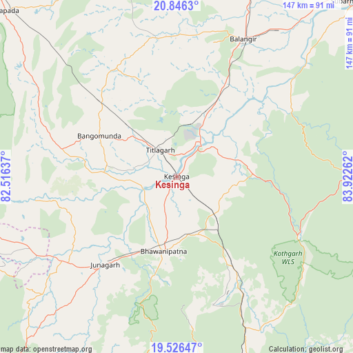
Kesinga GPS coordinates[2]
20° 11' 16.008" North, 83° 13' 10.164" East
| Map corner | latitude | longitude |
|---|---|---|
| Upper-left | 20.8463°, | 82.51637° |
| Center: | 20.18778°, | 83.21949° |
| Lower-right: | 19.52647°, | 83.92262° |
| Map W x H: | 146.8×146.8 km | = 91.2×91.2mi |
| max Lat: | 34.9274° ⇑64.6% North |
| Kesinga: | 20.18778° |
| min Lat: | ⇓35.4% South 8.09008° |
| min Long | Kesinga | max Long |
| 68.82655° | 83.21949° | 96.81° |
| W 80%⇐ | ⇒20% E |
Elevation
Elevation of Kesinga is 195 m = 640 ft, and this is 100.6 m = 330 ft below average elevation for this country.
| Max E: |
3681 m = 12077 ft | 51.3% |
| Avg. | 295.6 m = 970 ft | |
| Kesinga | 195 m = 640 ft | |
Min E: |
1 m = 3 ft | 48.7% |
See also: India elevation on elevation.city.
Geographical zone
Kesinga is located in North Torrid zone (between Equator and Tropic of Cancer). Distance of this Northern Tropic circle is 361.2 km =224.4 mi to North.| Distance of | km | miles | from Kesinga |
|---|---|---|---|
| North Pole | 7762.4 | 4823.3 | to North |
| Arctic Circle | 5156.5 | 3204.1 | to North |
| Tropic Cancer | 361.2 | 224.4 | to North |
| Equator | 2244.7 | 1394.8 | to South |


Nearby cities:
15 places around Kesinga: (largest is in red/bold)
• Balāngīr
64 km =39.8 mi,  26°
26°
• Barpāli
117.8 km =73.2 mi,  18°
18°
• Bhawānipatna
31.7 km =19.7 mi,  189°
189°
• Binka
111.8 km =69.5 mi, 33°
• Gudāri
110.4 km =68.6 mi,  147°
147°
• Jūnāgarh
47.1 km =29.3 mi,  219°
219°
• Kantābānji
44 km =27.3 mi,  314°
314°
• Kharhiāl
49.2 km =30.6 mi,  283°
283°
• Padampur
91.7 km =57 mi,  349°
349°
• Patnāgarh
58.6 km =36.4 mi, 351°
• Phulbāni
110.3 km =68.5 mi,  72°
72°
• Sonepur
102.1 km =63.4 mi,  45°
45°
• Tarabha
76.9 km =47.8 mi,  38°
38°
• Titlāgarh
13.3 km =8.3 mi,  328°
328°
• Udayagiri
120.2 km =74.7 mi,  93°
93°
Sources, notices
• [Note1] Compared only with cities in India existing in our database
• [Src1] Map data: © OpenStreetMap contributors (CC-BY-SA)
• [Src2] Other city data from geonames.org with taken over terms of usage.
• [Src3] Geographical zone / Annual Mean Temperature by Robert A. Rohde @ Wikipedia
