Chāmpa geodata
Chāmpa (Chhattisgarh) is a populated place; located in India in Asia/Kolkata (GMT+5.5) time zone. With population of 41,252 people, there are 1070 cities with bigger population in this country. Compared to other cities in India, 56.5% of cities are located further ↑North; 78.3% of cities are located further ←West and 60.4% of cities have lower elevation than Chāmpa. Note1


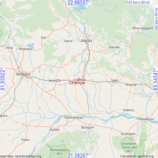
Chāmpa GPS coordinates[2]
22° 2' 7.152" North, 82° 38' 32.424" East
| Map corner | latitude | longitude |
|---|---|---|
| Upper-left | 22.68557°, | 81.93922° |
| Center: | 22.03532°, | 82.64234° |
| Lower-right: | 21.38207°, | 83.34547° |
| Map W x H: | 144.9×144.9 km | = 90×90mi |
| max Lat: | 34.9274° ⇑56.5% North |
| Chāmpa: | 22.03532° |
| min Lat: | ⇓43.5% South 8.09008° |
| min Long | Chāmpa | max Long |
| 68.82655° | 82.64234° | 96.81° |
| W 78.3%⇐ | ⇒21.7% E |
Elevation
Elevation of Chāmpa is 254 m = 833 ft, and this is 41.6 m = 136 ft below average elevation for this country.
| Max E: |
3681 m = 12077 ft | 39.6% |
| Avg. | 295.6 m = 970 ft | |
| Chāmpa | 254 m = 833 ft | |
Min E: |
1 m = 3 ft | 60.4% |
See also: Chāmpa elevation on elevation.city.
Geographical zone
Chāmpa is located in North Torrid zone (between Equator and Tropic of Cancer). Distance of this Northern Tropic circle is 155.8 km =96.8 mi to North.| Distance of | km | miles | from Chāmpa |
|---|---|---|---|
| North Pole | 7557 | 4695.7 | to North |
| Arctic Circle | 4951.1 | 3076.5 | to North |
| Tropic Cancer | 155.8 | 96.8 | to North |
| Equator | 2450.1 | 1522.4 | to South |


Nearby cities:
15 places around Chāmpa: (largest is in red/bold)
• Akaltara
22.3 km =13.9 mi,  266°
266°
• Baloda
20.2 km =12.6 mi,  304°
304°
• Baloda Bāzār
65.1 km =40.5 mi,  229°
229°
• Bilāspur
50.4 km =31.3 mi,  275°
275°
• Deori
65.1 km =40.5 mi,  182°
182°
• Jānjgīr
7.3 km =4.5 mi,  246°
246°
• Katghora
52.9 km =32.9 mi,  348°
348°
• Kharod
33 km =20.5 mi,  191°
191°
• Kharsia
47.9 km =29.8 mi,  96°
96°
• Korba
35 km =21.7 mi,  9°
9°
• Kotā
69.9 km =43.4 mi,  294°
294°
• Ratanpur
56.3 km =35 mi, 299°
• Saktī
32.8 km =20.4 mi,  91°
91°
• Seorīnārāyan
35.4 km =22 mi, 188°
• Sārangarh
67.2 km =41.8 mi,  137°
137°
Sources, notices
• [Note1] Compared only with cities in India existing in our database
• [Src1] Map data: © OpenStreetMap contributors (CC-BY-SA)
• [Src2] Other city data from geonames.org with taken over terms of usage.
• [Src3] Geographical zone / Annual Mean Temperature by Robert A. Rohde @ Wikipedia
