Korba geodata
Korba (Chhattisgarh) is a populated place; located in India in Asia/Kolkata (GMT+5.5) time zone. With population of 419,146 people, there are 109 cities with bigger population in this country. Compared to other cities in India, 54% of cities are located further ↑North; 78.5% of cities are located further ←West and 65.4% of cities have lower elevation than Korba. Note1


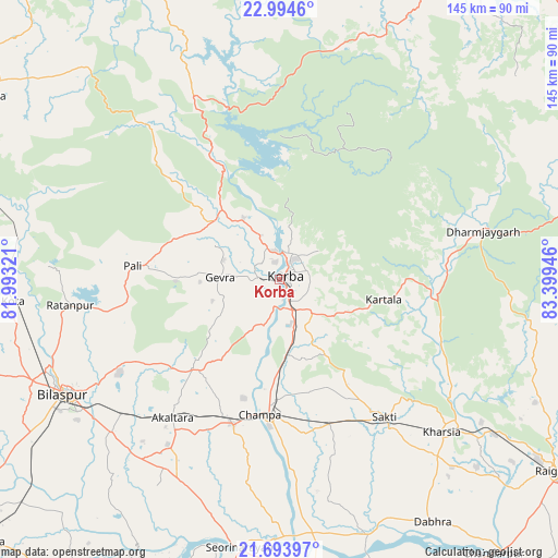
Korba GPS coordinates[2]
22° 20' 44.88" North, 82° 41' 46.788" East
| Map corner | latitude | longitude |
|---|---|---|
| Upper-left | 22.9946°, | 81.99321° |
| Center: | 22.3458°, | 82.69633° |
| Lower-right: | 21.69397°, | 83.39946° |
| Map W x H: | 144.6×144.6 km | = 89.9×89.9mi |
| max Lat: | 34.9274° ⇑54% North |
| Korba: | 22.3458° |
| min Lat: | ⇓46% South 8.09008° |
| min Long | Korba | max Long |
| 68.82655° | 82.69633° | 96.81° |
| W 78.5%⇐ | ⇒21.5% E |
Elevation
Elevation of Korba is 289 m = 948 ft, and this is 6.6 m = 22 ft below average elevation for this country.
| Max E: |
3681 m = 12077 ft | 34.6% |
| Avg. | 295.6 m = 970 ft | |
| Korba | 289 m = 948 ft | |
Min E: |
1 m = 3 ft | 65.4% |
See also: Korba elevation on elevation.city.
Geographical zone
Korba is located in North Torrid zone (between Equator and Tropic of Cancer). Distance of this Northern Tropic circle is 121.3 km =75.4 mi to North.| Distance of | km | miles | from Korba |
|---|---|---|---|
| North Pole | 7522.4 | 4674.2 | to North |
| Arctic Circle | 4916.6 | 3055 | to North |
| Tropic Cancer | 121.3 | 75.4 | to North |
| Equator | 2484.6 | 1543.9 | to South |


Nearby cities:
15 places around Korba: (largest is in red/bold)
• Akaltara
45.2 km =28.1 mi,  217°
217°
• Baloda
31.9 km =19.8 mi, 223°
• Bilāspur
63 km =39.1 mi,  242°
242°
• Chāmpa
35 km =21.7 mi,  189°
189°
• Gharghoda
70.1 km =43.6 mi,  105°
105°
• Jānjgīr
39.4 km =24.5 mi,  198°
198°
• Katghora
23.5 km =14.6 mi,  317°
317°
• Kharod
68 km =42.3 mi, 190°
• Kharsia
57.8 km =35.9 mi,  133°
133°
• Kotā
69.4 km =43.1 mi,  265°
265°
• Pasān
75.4 km =46.9 mi, 317°
• Pathalgaon
82.2 km =51.1 mi,  73°
73°
• Ratanpur
54.7 km =34 mi,  263°
263°
• Saktī
44.7 km =27.8 mi,  142°
142°
• Seorīnārāyan
70.3 km =43.7 mi, 188°
Sources, notices
• [Note1] Compared only with cities in India existing in our database
• [Src1] Map data: © OpenStreetMap contributors (CC-BY-SA)
• [Src2] Other city data from geonames.org with taken over terms of usage.
• [Src3] Geographical zone / Annual Mean Temperature by Robert A. Rohde @ Wikipedia
