Ābu Road geodata
Ābu Road (Rajasthan) is a populated place; located in India in Asia/Kolkata (GMT+5.5) time zone. With population of 50,262 people, there are 884 cities with bigger population in this country. Compared to other cities in India, 60.5% of cities are located further ↓South; 96% of cities are located further →East and 61.8% of cities have lower elevation than Ābu Road. Note1


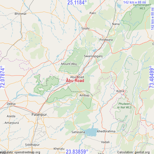
Ābu Road GPS coordinates[2]
24° 28' 48.432" North, 72° 46' 54.696" East
| Map corner | latitude | longitude |
|---|---|---|
| Upper-left | 25.1184°, | 72.07874° |
| Center: | 24.48012°, | 72.78186° |
| Lower-right: | 23.83859°, | 73.48499° |
| Map W x H: | 142.3×142.3 km | = 88.4×88.4mi |
| max Lat: | 34.9274° ⇑39.5% North |
| Ābu Road: | 24.48012° |
| min Lat: | ⇓60.5% South 8.09008° |
| min Long | Ābu Road | max Long |
| 68.82655° | 72.78186° | 96.81° |
| W 4%⇐ | ⇒96% E |
Elevation
Elevation of Ābu Road is 263 m = 863 ft, and this is 32.6 m = 107 ft below average elevation for this country.
| Max E: |
3681 m = 12077 ft | 38.2% |
| Avg. | 295.6 m = 970 ft | |
| Ābu Road | 263 m = 863 ft | |
Min E: |
1 m = 3 ft | 61.8% |
See also: Ābu Road elevation on elevation.city.
Geographical zone
Ābu Road is located in North temperate zone (between Tropic of Cancer and the Arctic Circle). Distance of this Northern Tropic circle is 116 km =72.1 mi to South.| Distance of | km | miles | from Ābu Road |
|---|---|---|---|
| North Pole | 7285.1 | 4526.7 | to North |
| Arctic Circle | 4679.2 | 2907.5 | to North |
| Tropic Cancer | 116 | 72.1 | to South |
| Equator | 2721.9 | 1691.3 | to South |


Nearby cities:
15 places around Ābu Road: (largest is in red/bold)
• Bhīnmāl
77.4 km =48.1 mi,  318°
318°
• Dhanera
76.8 km =47.7 mi,  272°
272°
• Dīsa
65.9 km =40.9 mi,  247°
247°
• Khedbrahma
56.8 km =35.3 mi,  151°
151°
• Kherālu
68.2 km =42.4 mi,  194°
194°
• Kānodar
58.6 km =36.4 mi,  222°
222°
• Pindwāra
44.8 km =27.8 mi,  38°
38°
• Pālanpur
48.9 km =30.4 mi,  225°
225°
• Sheoganj
78.8 km =49 mi,  21°
21°
• Siddhapur
75.1 km =46.7 mi,  213°
213°
• Sirohi
45.9 km =28.5 mi,  8°
8°
• Unjha
85 km =52.8 mi, 207°
• Vadnagar
78.5 km =48.8 mi, 190°
• Visnagar
90 km =55.9 mi,  195°
195°
• Ābu
14.2 km =8.8 mi,  332°
332°
Sources, notices
• [Note1] Compared only with cities in India existing in our database
• [Src1] Map data: © OpenStreetMap contributors (CC-BY-SA)
• [Src2] Other city data from geonames.org with taken over terms of usage.
• [Src3] Geographical zone / Annual Mean Temperature by Robert A. Rohde @ Wikipedia
