Ābu geodata
Ābu (Rajasthan) is a populated place; located in India in Asia/Kolkata (GMT+5.5) time zone. With population of 24,981 people, there are 1705 cities with bigger population in this country. Compared to other cities in India, 61.2% of cities are located further ↓South; 96.3% of cities are located further →East and 96.8% of cities have lower elevation than Ābu. Note1


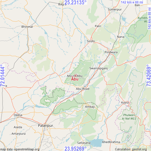
Ābu GPS coordinates[2]
24° 35' 37.14" North, 72° 43' 3.216" East
| Map corner | latitude | longitude |
|---|---|---|
| Upper-left | 25.23135°, | 72.01444° |
| Center: | 24.59365°, | 72.71756° |
| Lower-right: | 23.95269°, | 73.42069° |
| Map W x H: | 142.2×142.2 km | = 88.4×88.4mi |
| max Lat: | 34.9274° ⇑38.8% North |
| Ābu: | 24.59365° |
| min Lat: | ⇓61.2% South 8.09008° |
| min Long | Ābu | max Long |
| 68.82655° | 72.71756° | 96.81° |
| W 3.7%⇐ | ⇒96.3% E |
Elevation
Elevation of Ābu is 1181 m = 3875 ft, and this is 885.4 m = 2905 ft above average elevation for this country.
| Max E: |
3681 m = 12077 ft | 3.2% |
| Ābu | 1181 m 3875 ft | |
| Avg. | 295.6 m = 970 ft | |
Min E: |
1 m = 3 ft | 96.8% |
See also: India elevation on elevation.city.
Geographical zone
Ābu is located in North temperate zone (between Tropic of Cancer and the Arctic Circle). Distance of this Northern Tropic circle is 128.6 km =79.9 mi to South.| Distance of | km | miles | from Ābu |
|---|---|---|---|
| North Pole | 7272.5 | 4518.9 | to North |
| Arctic Circle | 4666.6 | 2899.7 | to North |
| Tropic Cancer | 128.6 | 79.9 | to South |
| Equator | 2734.6 | 1699.2 | to South |


Nearby cities:
15 places around Ābu: (largest is in red/bold)
• Bhīnmāl
63.7 km =39.6 mi,  315°
315°
• Bāli
88.6 km =55.1 mi,  40°
40°
• Dhanera
70.8 km =44 mi,  262°
262°
• Dīsa
66.2 km =41.1 mi,  235°
235°
• Jalor
84.2 km =52.3 mi,  352°
352°
• Khedbrahma
71 km =44.1 mi,  152°
152°
• Kherālu
79.4 km =49.3 mi,  187°
187°
• Kānodar
65 km =40.4 mi,  210°
210°
• Pindwāra
40.9 km =25.4 mi,  56°
56°
• Pālanpur
54.8 km =34.1 mi, 211°
• Sheoganj
70.2 km =43.6 mi,  30°
30°
• Siddhapur
82.9 km =51.5 mi,  204°
204°
• Sirohi
35.3 km =21.9 mi,  21°
21°
• Takhatgarh
86 km =53.4 mi, 19°
• Ābu Road
14.2 km =8.8 mi, 152°
Sources, notices
• [Note1] Compared only with cities in India existing in our database
• [Src1] Map data: © OpenStreetMap contributors (CC-BY-SA)
• [Src2] Other city data from geonames.org with taken over terms of usage.
• [Src3] Geographical zone / Annual Mean Temperature by Robert A. Rohde @ Wikipedia
