Hazāribāgh geodata
Hazāribāgh (Jharkhand) is a populated place; located in India in Asia/Kolkata (GMT+5.5) time zone. With population of 140,063 people, there are 307 cities with bigger population in this country. Compared to other cities in India, 58.1% of cities are located further ↓South; 85.2% of cities are located further ←West and 89.3% of cities have lower elevation than Hazāribāgh. Note1


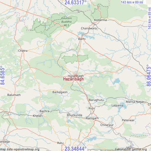
Hazāribāgh GPS coordinates[2]
23° 59' 32.676" North, 85° 21' 41.832" East
| Map corner | latitude | longitude |
|---|---|---|
| Upper-left | 24.63317°, | 84.6585° |
| Center: | 23.99241°, | 85.36162° |
| Lower-right: | 23.34844°, | 86.06475° |
| Map W x H: | 142.8×142.9 km | = 88.7×88.8mi |
| max Lat: | 34.9274° ⇑41.9% North |
| Hazāribāgh: | 23.99241° |
| min Lat: | ⇓58.1% South 8.09008° |
| min Long | Hazāribāgh | max Long |
| 68.82655° | 85.36162° | 96.81° |
| W 85.2%⇐ | ⇒14.8% E |
Elevation
Elevation of Hazāribāgh is 621 m = 2037 ft, and this is 325.4 m = 1068 ft above average elevation for this country.
| Max E: |
3681 m = 12077 ft | 10.7% |
| Hazāribāgh | 621 m 2037 ft | |
| Avg. | 295.6 m = 970 ft | |
Min E: |
1 m = 3 ft | 89.3% |
See also: Hazāribāgh elevation on elevation.city.
Geographical zone
Hazāribāgh is located in North temperate zone (between Tropic of Cancer and the Arctic Circle). Distance of this Northern Tropic circle is 61.8 km =38.4 mi to South.| Distance of | km | miles | from Hazāribāgh |
|---|---|---|---|
| North Pole | 7339.4 | 4560.5 | to North |
| Arctic Circle | 4733.5 | 2941.3 | to North |
| Tropic Cancer | 61.8 | 38.4 | to South |
| Equator | 2667.7 | 1657.6 | to South |


Nearby cities:
15 places around Hazāribāgh: (largest is in red/bold)
• Bagaha
67 km =41.6 mi,  332°
332°
• Barki Saria
57.3 km =35.6 mi,  69°
69°
• Barkā Kānā
42.7 km =26.5 mi,  165°
165°
• Bokāro
64.6 km =40.1 mi,  110°
110°
• Chatrā
55.2 km =34.3 mi,  295°
295°
• Gumia
51.9 km =32.2 mi, 114°
• Hesla
53.1 km =33 mi,  81°
81°
• Jumri Tilaiyā
52.1 km =32.4 mi,  19°
19°
• Kodarmā
57.8 km =35.9 mi, 24°
• Kuju
33.3 km =20.7 mi,  153°
153°
• Kānke
62.1 km =38.6 mi,  183°
183°
• Rāmgarh
43.4 km =27 mi,  157°
157°
• Rāy
46.4 km =28.8 mi,  222°
222°
• Sāruberā
67.4 km =41.9 mi, 106°
• patamda
34.7 km =21.6 mi,  9°
9°
Sources, notices
• [Note1] Compared only with cities in India existing in our database
• [Src1] Map data: © OpenStreetMap contributors (CC-BY-SA)
• [Src2] Other city data from geonames.org with taken over terms of usage.
• [Src3] Geographical zone / Annual Mean Temperature by Robert A. Rohde @ Wikipedia
