Rāpar geodata
Rāpar (Gujarat) is a populated place; located in India in Asia/Kolkata (GMT+5.5) time zone. With population of 21,507 people, there are 1934 cities with bigger population in this country. Compared to other cities in India, 55.3% of cities are located further ↓South; 98.9% of cities are located further →East and 75.7% of cities have higher elevation than Rāpar. Note1


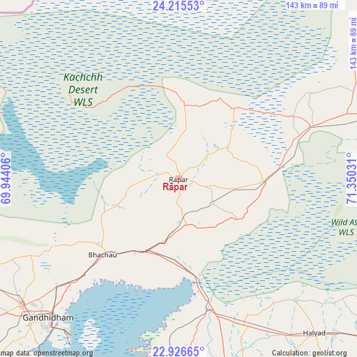
Rāpar GPS coordinates[2]
23° 34' 21.612" North, 70° 38' 49.848" East
| Map corner | latitude | longitude |
|---|---|---|
| Upper-left | 24.21553°, | 69.94406° |
| Center: | 23.57267°, | 70.64718° |
| Lower-right: | 22.92665°, | 71.35031° |
| Map W x H: | 143.3×143.3 km | = 89×89mi |
| max Lat: | 34.9274° ⇑44.7% North |
| Rāpar: | 23.57267° |
| min Lat: | ⇓55.3% South 8.09008° |
| min Long | Rāpar | max Long |
| 68.82655° | 70.64718° | 96.81° |
| W 1.1%⇐ | ⇒98.9% E |
Elevation
Elevation of Rāpar is 65 m = 213 ft, and this is 230.6 m = 757 ft below average elevation for this country.
| Max E: |
3681 m = 12077 ft | 75.7% |
| Avg. | 295.6 m = 970 ft | |
| Rāpar | 65 m = 213 ft | |
Min E: |
1 m = 3 ft | 24.3% |
See also: India elevation on elevation.city.
Geographical zone
Rāpar is located in North temperate zone (between Tropic of Cancer and the Arctic Circle). Distance of this Northern Tropic circle is 15.1 km =9.4 mi to South.| Distance of | km | miles | from Rāpar |
|---|---|---|---|
| North Pole | 7386 | 4589.4 | to North |
| Arctic Circle | 4780.1 | 2970.2 | to North |
| Tropic Cancer | 15.1 | 9.4 | to South |
| Equator | 2621 | 1628.6 | to South |


Nearby cities:
15 places around Rāpar: (largest is in red/bold)
• Anjār
81.4 km =50.6 mi,  231°
231°
• Bhachāu
43.5 km =27 mi, 225°
• Bhuj
105.9 km =65.8 mi,  250°
250°
• Dhrol
114.3 km =71 mi,  191°
191°
• Dhrāngadhra
105.8 km =65.7 mi,  127°
127°
• Gāndhīdhām
75.6 km =47 mi,  223°
223°
• Halvad
82.5 km =51.3 mi,  138°
138°
• Jodiya Bandar
102.2 km =63.5 mi,  201°
201°
• Kāndla
74.4 km =46.2 mi, 216°
• Morbi
86.2 km =53.6 mi,  166°
166°
• Rādhanpur
101.7 km =63.2 mi,  73°
73°
• Tankāra
102.4 km =63.6 mi, 174°
• Thān
124.6 km =77.4 mi,  153°
153°
• Un
119.5 km =74.3 mi, 72°
• Wānkāner
111 km =69 mi,  164°
164°
Sources, notices
• [Note1] Compared only with cities in India existing in our database
• [Src1] Map data: © OpenStreetMap contributors (CC-BY-SA)
• [Src2] Other city data from geonames.org with taken over terms of usage.
• [Src3] Geographical zone / Annual Mean Temperature by Robert A. Rohde @ Wikipedia
