Bhachāu geodata
Bhachāu (Gujarat) is a populated place; located in India in Asia/Kolkata (GMT+5.5) time zone. With population of 24,044 people, there are 1771 cities with bigger population in this country. Compared to other cities in India, 53.6% of cities are located further ↓South; 99.2% of cities are located further →East and 81.1% of cities have higher elevation than Bhachāu. Note1


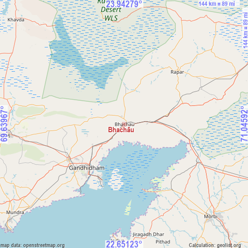
Bhachāu GPS coordinates[2]
23° 17' 54.888" North, 70° 20' 34.044" East
| Map corner | latitude | longitude |
|---|---|---|
| Upper-left | 23.94279°, | 69.63967° |
| Center: | 23.29858°, | 70.34279° |
| Lower-right: | 22.65123°, | 71.04592° |
| Map W x H: | 143.6×143.6 km | = 89.2×89.2mi |
| max Lat: | 34.9274° ⇑46.4% North |
| Bhachāu: | 23.29858° |
| min Lat: | ⇓53.6% South 8.09008° |
| min Long | Bhachāu | max Long |
| 68.82655° | 70.34279° | 96.81° |
| W 0.8%⇐ | ⇒99.2% E |
Elevation
Elevation of Bhachāu is 44 m = 144 ft, and this is 251.6 m = 825 ft below average elevation for this country.
| Max E: |
3681 m = 12077 ft | 81.1% |
| Avg. | 295.6 m = 970 ft | |
| Bhachāu | 44 m = 144 ft | |
Min E: |
1 m = 3 ft | 18.9% |
See also: India elevation on elevation.city.
Geographical zone
Bhachāu is located in North Torrid zone (between Equator and Tropic of Cancer). Distance of this Northern Tropic circle is 15.4 km =9.6 mi to North.| Distance of | km | miles | from Bhachāu |
|---|---|---|---|
| North Pole | 7416.5 | 4608.4 | to North |
| Arctic Circle | 4810.6 | 2989.2 | to North |
| Tropic Cancer | 15.4 | 9.6 | to North |
| Equator | 2590.6 | 1609.7 | to South |


Nearby cities:
15 places around Bhachāu: (largest is in red/bold)
• Anjār
38.3 km =23.8 mi,  237°
237°
• Bedi
93.8 km =58.3 mi,  199°
199°
• Bhuj
69 km =42.9 mi,  265°
265°
• Dhrol
81.7 km =50.8 mi,  174°
174°
• Gāndhīdhām
32.1 km =19.9 mi,  221°
221°
• Halvad
91.2 km =56.7 mi,  110°
110°
• Jamnagar
96.1 km =59.7 mi, 197°
• Jodiya Bandar
65 km =40.4 mi,  185°
185°
• Kāndla
32.2 km =20 mi, 203°
• Morbi
73.7 km =45.8 mi,  136°
136°
• Mundra
81.5 km =50.6 mi,  231°
231°
• Paddhari
99.5 km =61.8 mi,  164°
164°
• Rāpar
43.5 km =27 mi,  45°
45°
• Tankāra
82.7 km =51.4 mi,  149°
149°
• Wānkāner
98.1 km =61 mi, 141°
Sources, notices
• [Note1] Compared only with cities in India existing in our database
• [Src1] Map data: © OpenStreetMap contributors (CC-BY-SA)
• [Src2] Other city data from geonames.org with taken over terms of usage.
• [Src3] Geographical zone / Annual Mean Temperature by Robert A. Rohde @ Wikipedia
