Lohāru geodata
Lohāru (Haryana) is a populated place; located in India in Asia/Kolkata (GMT+5.5) time zone. With population of 12,410 people, there are 2710 cities with bigger population in this country. Compared to other cities in India, 86.4% of cities are located further ↓South; 75.6% of cities are located further →East and 63.4% of cities have lower elevation than Lohāru. Note1


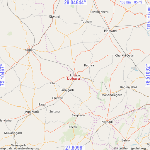
Lohāru GPS coordinates[2]
28° 25' 47.748" North, 75° 48' 28.044" East
| Map corner | latitude | longitude |
|---|---|---|
| Upper-left | 29.04644°, | 75.10467° |
| Center: | 28.42993°, | 75.80779° |
| Lower-right: | 27.8098°, | 76.51092° |
| Map W x H: | 137.5×137.5 km | = 85.4×85.4mi |
| max Lat: | 34.9274° ⇑13.6% North |
| Lohāru: | 28.42993° |
| min Lat: | ⇓86.4% South 8.09008° |
| min Long | Lohāru | max Long |
| 68.82655° | 75.80779° | 96.81° |
| W 24.4%⇐ | ⇒75.6% E |
Elevation
Elevation of Lohāru is 275 m = 902 ft, and this is 20.6 m = 68 ft below average elevation for this country.
| Max E: |
3681 m = 12077 ft | 36.6% |
| Avg. | 295.6 m = 970 ft | |
| Lohāru | 275 m = 902 ft | |
Min E: |
1 m = 3 ft | 63.4% |
See also: India elevation on elevation.city.
Geographical zone
Lohāru is located in North temperate zone (between Tropic of Cancer and the Arctic Circle). Distance of this Northern Tropic circle is 555.2 km =345 mi to South.| Distance of | km | miles | from Lohāru |
|---|---|---|---|
| North Pole | 6846 | 4253.9 | to North |
| Arctic Circle | 4240.1 | 2634.7 | to North |
| Tropic Cancer | 555.2 | 345 | to South |
| Equator | 3161.1 | 1964.2 | to South |


Nearby cities:
15 places around Lohāru: (largest is in red/bold)
• Ateli Mandi
57.4 km =35.7 mi,  129°
129°
• Bagar
40.4 km =25.1 mi,  228°
228°
• Bhiwāni
51.8 km =32.2 mi,  38°
38°
• Charkhi Dādri
48.8 km =30.3 mi,  68°
68°
• Chidawa
26.8 km =16.7 mi,  217°
217°
• Jhunjhunūn
52.5 km =32.6 mi, 229°
• Kanīna Khās
50.4 km =31.3 mi,  102°
102°
• Khetri
47.8 km =29.7 mi,  182°
182°
• Mahendragarh
38.2 km =23.7 mi,  117°
117°
• Mandholi Kalān
33.3 km =20.7 mi,  338°
338°
• Nārnaul
52 km =32.3 mi,  145°
145°
• Pilāni
21.2 km =13.2 mi,  250°
250°
• Rājgarh
47.5 km =29.5 mi,  299°
299°
• Sūrajgarh
15.2 km =9.4 mi,  208°
208°
• Toshām
50.1 km =31.1 mi,  12°
12°
Sources, notices
• [Note1] Compared only with cities in India existing in our database
• [Src1] Map data: © OpenStreetMap contributors (CC-BY-SA)
• [Src2] Other city data from geonames.org with taken over terms of usage.
• [Src3] Geographical zone / Annual Mean Temperature by Robert A. Rohde @ Wikipedia
