Nārnaul geodata
Nārnaul (Haryana) is a populated place; located in India in Asia/Kolkata (GMT+5.5) time zone. With population of 66,049 people, there are 659 cities with bigger population in this country. Compared to other cities in India, 84.7% of cities are located further ↓South; 72.6% of cities are located further →East and 68.4% of cities have lower elevation than Nārnaul. Note1


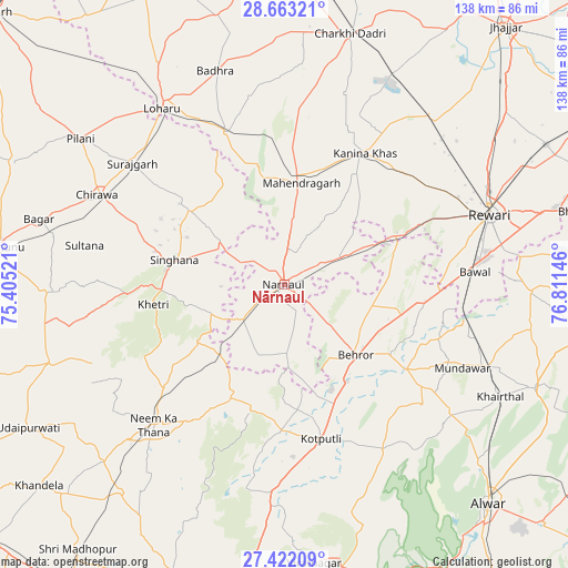
Nārnaul GPS coordinates[2]
28° 2' 39.984" North, 76° 6' 29.988" East
| Map corner | latitude | longitude |
|---|---|---|
| Upper-left | 28.66321°, | 75.40521° |
| Center: | 28.04444°, | 76.10833° |
| Lower-right: | 27.42209°, | 76.81146° |
| Map W x H: | 138×138 km | = 85.7×85.7mi |
| max Lat: | 34.9274° ⇑15.3% North |
| Nārnaul: | 28.04444° |
| min Lat: | ⇓84.7% South 8.09008° |
| min Long | Nārnaul | max Long |
| 68.82655° | 76.10833° | 96.81° |
| W 27.4%⇐ | ⇒72.6% E |
Elevation
Elevation of Nārnaul is 311 m = 1020 ft, and this is 15.4 m = 51 ft above average elevation for this country.
| Max E: |
3681 m = 12077 ft | 31.6% |
| Nārnaul | 311 m 1020 ft | |
| Avg. | 295.6 m = 970 ft | |
Min E: |
1 m = 3 ft | 68.4% |
See also: Nārnaul elevation on elevation.city.
Geographical zone
Nārnaul is located in North temperate zone (between Tropic of Cancer and the Arctic Circle). Distance of this Northern Tropic circle is 512.3 km =318.3 mi to South.| Distance of | km | miles | from Nārnaul |
|---|---|---|---|
| North Pole | 6888.8 | 4280.5 | to North |
| Arctic Circle | 4282.9 | 2661.3 | to North |
| Tropic Cancer | 512.3 | 318.3 | to South |
| Equator | 3118.2 | 1937.6 | to South |


Nearby cities:
15 places around Nārnaul: (largest is in red/bold)
• Ateli Mandi
16.1 km =10 mi,  67°
67°
• Bagar
61.7 km =38.3 mi,  284°
284°
• Behror
24.3 km =15.1 mi,  135°
135°
• Bāwal
46.7 km =29 mi,  86°
86°
• Chidawa
50.7 km =31.5 mi,  295°
295°
• Kanīna Khās
37.5 km =23.3 mi,  31°
31°
• Khetri
32 km =19.9 mi,  261°
261°
• Kotputli
39.1 km =24.3 mi,  166°
166°
• Lohāru
52 km =32.3 mi,  325°
325°
• Mahendragarh
25.4 km =15.8 mi,  9°
9°
• Mandāwar
47.8 km =29.7 mi,  114°
114°
• Neem ka Thana
46.3 km =28.8 mi,  223°
223°
• Pilāni
61.1 km =38 mi,  305°
305°
• Rewāri
52.9 km =32.9 mi, 71°
• Sūrajgarh
47.2 km =29.3 mi, 308°
Sources, notices
• [Note1] Compared only with cities in India existing in our database
• [Src1] Map data: © OpenStreetMap contributors (CC-BY-SA)
• [Src2] Other city data from geonames.org with taken over terms of usage.
• [Src3] Geographical zone / Annual Mean Temperature by Robert A. Rohde @ Wikipedia
