Sihorā geodata
Sihorā (Madhya Pradesh) is a populated place; located in India in Asia/Kolkata (GMT+5.5) time zone. With population of 41,192 people, there are 1074 cities with bigger population in this country. Compared to other cities in India, 54.8% of cities are located further ↓South; 68.6% of cities are located further ←West and 75.3% of cities have lower elevation than Sihorā. Note1


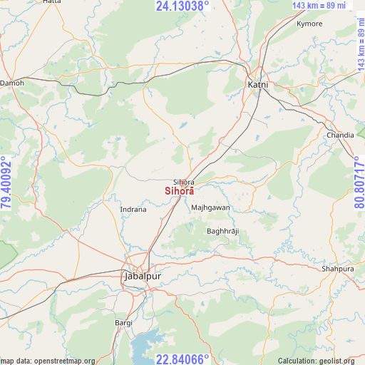
Sihorā GPS coordinates[2]
23° 29' 13.56" North, 80° 6' 14.544" East
| Map corner | latitude | longitude |
|---|---|---|
| Upper-left | 24.13038°, | 79.40092° |
| Center: | 23.4871°, | 80.10404° |
| Lower-right: | 22.84066°, | 80.80717° |
| Map W x H: | 143.4×143.4 km | = 89.1×89.1mi |
| max Lat: | 34.9274° ⇑45.2% North |
| Sihorā: | 23.4871° |
| min Lat: | ⇓54.8% South 8.09008° |
| min Long | Sihorā | max Long |
| 68.82655° | 80.10404° | 96.81° |
| W 68.6%⇐ | ⇒31.4% E |
Elevation
Elevation of Sihorā is 391 m = 1283 ft, and this is 95.4 m = 313 ft above average elevation for this country.
| Max E: |
3681 m = 12077 ft | 24.7% |
| Sihorā | 391 m 1283 ft | |
| Avg. | 295.6 m = 970 ft | |
Min E: |
1 m = 3 ft | 75.3% |
See also: Sihorā elevation on elevation.city.
Geographical zone
Sihorā is located in North temperate zone (between Tropic of Cancer and the Arctic Circle). Distance of this Northern Tropic circle is 5.6 km =3.5 mi to South.| Distance of | km | miles | from Sihorā |
|---|---|---|---|
| North Pole | 7395.5 | 4595.3 | to North |
| Arctic Circle | 4789.7 | 2976.2 | to North |
| Tropic Cancer | 5.6 | 3.5 | to South |
| Equator | 2611.5 | 1622.7 | to South |


Nearby cities:
15 places around Sihorā: (largest is in red/bold)
• Barela
43.7 km =27.2 mi,  187°
187°
• Bargi
59.9 km =37.2 mi,  202°
202°
• Chandia
64.5 km =40.1 mi,  73°
73°
• Hindoria
71.5 km =44.4 mi,  310°
310°
• Jabalpur
38.9 km =24.2 mi, 203°
• Kaimori
38.4 km =23.9 mi,  252°
252°
• Katangi
31.8 km =19.8 mi,  260°
260°
• Khamaria
37 km =23 mi,  218°
218°
• Majholi
18.4 km =11.4 mi,  274°
274°
• Murwāra
48.9 km =30.4 mi,  37°
37°
• Panāgar
25 km =15.5 mi,  206°
206°
• Pātan
47.8 km =29.7 mi,  242°
242°
• Shāhpura
59.5 km =37 mi,  229°
229°
• Tendūkheda
58.5 km =36.4 mi, 260°
• Umaria
74.9 km =46.5 mi,  86°
86°
Sources, notices
• [Note1] Compared only with cities in India existing in our database
• [Src1] Map data: © OpenStreetMap contributors (CC-BY-SA)
• [Src2] Other city data from geonames.org with taken over terms of usage.
• [Src3] Geographical zone / Annual Mean Temperature by Robert A. Rohde @ Wikipedia
