Panāgar geodata
Panāgar (Madhya Pradesh) is a populated place; located in India in Asia/Kolkata (GMT+5.5) time zone. With population of 26,619 people, there are 1604 cities with bigger population in this country. Compared to other cities in India, 53.4% of cities are located further ↓South; 67.7% of cities are located further ←West and 75.3% of cities have lower elevation than Panāgar. Note1


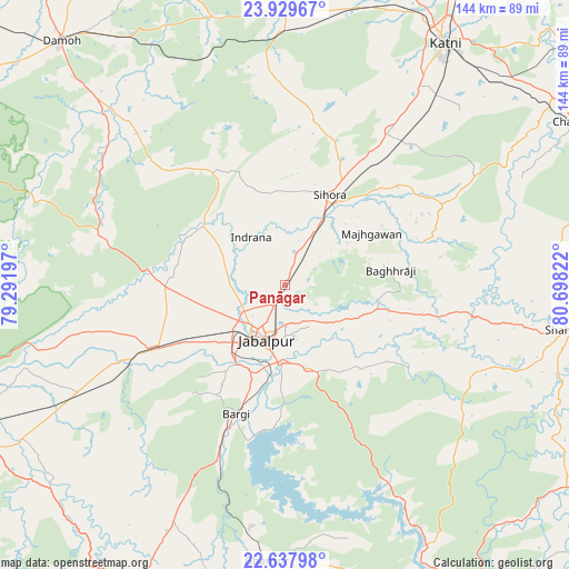
Panāgar GPS coordinates[2]
23° 17' 7.404" North, 79° 59' 42.324" East
| Map corner | latitude | longitude |
|---|---|---|
| Upper-left | 23.92967°, | 79.29197° |
| Center: | 23.28539°, | 79.99509° |
| Lower-right: | 22.63798°, | 80.69822° |
| Map W x H: | 143.6×143.6 km | = 89.2×89.2mi |
| max Lat: | 34.9274° ⇑46.6% North |
| Panāgar: | 23.28539° |
| min Lat: | ⇓53.4% South 8.09008° |
| min Long | Panāgar | max Long |
| 68.82655° | 79.99509° | 96.81° |
| W 67.7%⇐ | ⇒32.3% E |
Elevation
Elevation of Panāgar is 391 m = 1283 ft, and this is 95.4 m = 313 ft above average elevation for this country.
| Max E: |
3681 m = 12077 ft | 24.7% |
| Panāgar | 391 m 1283 ft | |
| Avg. | 295.6 m = 970 ft | |
Min E: |
1 m = 3 ft | 75.3% |
See also: India elevation on elevation.city.
Geographical zone
Panāgar is located in North Torrid zone (between Equator and Tropic of Cancer). Distance of this Northern Tropic circle is 16.8 km =10.4 mi to North.| Distance of | km | miles | from Panāgar |
|---|---|---|---|
| North Pole | 7418 | 4609.3 | to North |
| Arctic Circle | 4812.1 | 2990.1 | to North |
| Tropic Cancer | 16.8 | 10.4 | to North |
| Equator | 2589.1 | 1608.8 | to South |


Nearby cities:
15 places around Panāgar: (largest is in red/bold)
• Barela
21.7 km =13.5 mi,  164°
164°
• Bargi
34.9 km =21.7 mi,  200°
200°
• Damoh
83 km =51.6 mi,  317°
317°
• Ghansor
69.7 km =43.3 mi,  183°
183°
• Hindoria
81.3 km =50.5 mi,  327°
327°
• Jabalpur
13.9 km =8.6 mi, 199°
• Kaimori
27.9 km =17.3 mi,  293°
293°
• Katangi
26.7 km =16.6 mi,  310°
310°
• Khamaria
13.5 km =8.4 mi,  240°
240°
• Majholi
25.1 km =15.6 mi,  343°
343°
• Murwāra
73.7 km =45.8 mi,  33°
33°
• Pātan
31.2 km =19.4 mi,  270°
270°
• Shāhpura
37.7 km =23.4 mi, 243°
• Sihorā
25 km =15.5 mi, 26°
• Tendūkheda
48.1 km =29.9 mi,  284°
284°
Sources, notices
• [Note1] Compared only with cities in India existing in our database
• [Src1] Map data: © OpenStreetMap contributors (CC-BY-SA)
• [Src2] Other city data from geonames.org with taken over terms of usage.
• [Src3] Geographical zone / Annual Mean Temperature by Robert A. Rohde @ Wikipedia
